Medina, Isle of Wight

Medina, Isle of Wight
Medina
Motto: Floreat Medina (May Medina flourish)
Geography
Status non-metropolitan district, borough
1974 area 28,949 acres (117.15 km2)[1]
HQ Newport
History
Created 1974
Abolished 1995
Succeeded by Isle of Wight
Demography
1973[2] population 64,790
1992[3] population 72,000
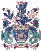
The Arms of Medina Borough Council

Medina was a non-metropolitan district with the status of a borough on the Isle of Wight in England from 1974 to 1995.

The district was formed by the Local Government Act 1972, and was a merger of the municipal boroughs of Newport and Ryde along with the urban district of Cowes. It was one of two districts on the Island formed in 1974 - the other was South Wight.

"Medina" was an older name for Newport which has been preserved in the River Medina.

Following a review by the Local Government Commission for England, the borough was abolished on 1 April 1995, when a single Isle of Wight Council replaced the Island's county council and two district councils.[4]


References

  1. ^ Local government in England and Wales: A Guide to the New System. London: HMSO. 1974. p. 61. ISBN 0117508470. 
  2. ^ Registrar General's annual estimated figure mid 1973
  3. ^ OPCS Key Population and Vital Statistics 1992
  4. ^ "The Isle of Wight (Structural Change) Order 1994". Office of Public Sector Information. 2004. http://www.opsi.gov.uk/si/si1994/Uksi_19941210_en_1.htm. Retrieved 12 January 2009. 

Coordinates: 50°40′59″N 1°32′24″W / 50.6830°N 1.5401°W / 50.6830; -1.5401


Wikimedia Foundation. 2010.

Игры ⚽ Поможем написать курсовую

Look at other dictionaries:

  • Isle of wight — Basisdaten Status Unitary Authority Zeremonielle Grafschaft Region South East England …   Deutsch Wikipedia

  • Isle of Wight — Flagge Lage Basisdaten Status Unitary Authority …   Deutsch Wikipedia

  • Isle of Wight Central Railway — See also: Railways on the Isle of Wight [v · d · …   Wikipedia

  • Isle of Wight — Infobox England county name = Isle of Wight motto = All this beauty is of God status = Ceremonial Non metropolitan/Unitary county origin = region = South East England arearank = Ranked 46th area km2 = 380 adminarearank = adminarea km2 = adminhq …   Wikipedia

  • Isle of Wight Railway — The Isle of Wight Railway (IoWR) was opened on 23 August 1864. It had a total length of 14.5 miles from Ryde to Ventnor and a branch line from Brading to Bembridge. It had junctions with the Isle of Wight Central Railway (IoWCR) at Smallbrook… …   Wikipedia

  • Isle of Wight Festival — infobox music festival music festival name = Isle Of Wight Festival location = England, Seaclose Park years active= 1968 1970 / 2002 Present dates = At the beginning of June genre = Rock, Alternative rock website = [http://www.isleofwightfestival …   Wikipedia

  • Isle of Wight Festival 2005 — The Isle of Wight Festival 2005 is the fourth revived Isle of Wight Festival on the Seaclose Park site in Newport on the Isle of Wight. The attendance of this festival was around 50,000, a 15,000 increase on sales of the year before, which was… …   Wikipedia

  • Isle of Wight College — Coordinates: 50°42′22″N 1°17′49″W / 50.706°N 1.297°W / 50.706; 1.297 …   Wikipedia

  • Isle of Wight Festival 2007 — The Isle of Wight Festival 2007 was the sixth revived Isle of Wight Festival on the Seaclose Park site in Newport on the Isle of Wight. It took place between 8 June 10 June 2007. Tickets went on sale at 9am on Thursday 22 February and were sold… …   Wikipedia

  • Isle of Wight Council — The Isle of Wight Council is a local council. It is a unitary authority covering the Isle of Wight, South East England.The council was formed on April 1, 1995, as a continuation of the old Isle of Wight County Council, which became a unitary… …   Wikipedia

Share the article and excerpts

Direct link
Do a right-click on the link above
and select “Copy Link”