Comprégnac

Comprégnac

Comprégnac

FR-12-Comprégnac1.JPG
Comprégnac is located in France
{{{alt}}}
Comprégnac
Administration
Country France
Region Midi-Pyrénées
Department Aveyron
Arrondissement Millau
Canton Millau-Ouest
Intercommunality Millau Grands Causses
Mayor Jean-Paul Hatsch
(2008–2014)
Statistics
Elevation 340–701 m (1,120–2,300 ft)
(avg. 335 m/1,099 ft)
Land area1 11.09 km2 (4.28 sq mi)
Population2 236  (2008)
 - Density 21 /km2 (54 /sq mi)
INSEE/Postal code 12072/ 12100
1 French Land Register data, which excludes lakes, ponds, glaciers > 1 km² (0.386 sq mi or 247 acres) and river estuaries.
2 Population without double counting: residents of multiple communes (e.g., students and military personnel) only counted once.

Coordinates: 44°05′01″N 2°57′43″E / 44.0836111111°N 2.96194444444°E / 44.0836111111; 2.96194444444

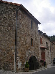
Comprégnac is a commune in the Aveyron department in southern France.

The village of Peyre is part of the commune of Comprégnac. It belongs to The most beautiful villages of France association.

Population

Historical population of Comprégnac
1962 1968 1975 1982 1990 1999 2008
106 141 114 133 178 215 236

See also

References


Wikimedia Foundation. 2010.

Игры ⚽ Поможем сделать НИР

Look at other dictionaries:

  • Compregnac — Comprégnac Comprégnac Pays  Fra …   Wikipédia en Français

  • Comprégnac — Comprenhac País …   Wikipedia Español

  • Comprégnac — 44° 05′ 01″ N 2° 57′ 43″ E / 44.0836, 2.9619 …   Wikipédia en Français

  • Peyre (Aveyron) — Pour les articles homonymes, voir Peyre. Peyre Village troglodyte de Peyre Administrati …   Wikipédia en Français

  • Millau —  Pour l’article homophone, voir Millot. 44° 05′ 55″ N 3° 04′ 42″ E …   Wikipédia en Français

  • Aguessac — 44° 09′ 27″ N 3° 05′ 57″ E / 44.1575, 3.09916666667 …   Wikipédia en Français

  • Compeyre — 44° 09′ 42″ N 3° 06′ 09″ E / 44.1617, 3.1025 …   Wikipédia en Français

  • Condutomagus — Millau  Pour l’article homophone, voir Millot. Millau Vue générale de la ville …   Wikipédia en Français

  • Creissels — est une commune française, située dans le département de l’Aveyron et la région Midi Pyrénées. Elle fait donc partie de l ancienne province du Rouergue ou l on communique grâce à une forme d Occitan: le patois ou dialecte rouergat. Ses habitants… …   Wikipédia en Français

  • La Cresse — 44° 10′ 43″ N 3° 07′ 50″ E / 44.1786111111, 3.13055555556 …   Wikipédia en Français

Share the article and excerpts

Direct link
Do a right-click on the link above
and select “Copy Link”