- Casa Malpaís
Infobox_nrhp | name =Casa Malpaís Site
nrhp_type = nhl
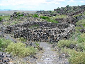
caption = The Kiva
nearest_city=Springerville, Arizona
locmapin = Arizona
lat_degrees = 34 | lat_minutes = 09 | lat_direction = N
long_degrees = 109 | long_minutes = 18 | long_direction = W
area =
built =1250
architect=
architecture =
designated=July 19 ,1964 cite web|url=http://tps.cr.nps.gov/nhl/detail.cfm?ResourceId=709&ResourceType=Site
title=Casa Malpais Site|date=2007-09-27|work=National Historic Landmark summary listing|publisher=National Park Service]
added =October 15 ,1966 cite web|url=http://www.nr.nps.gov/|title=National Register Information System|date=2007-01-23|work=National Register of Historic Places|publisher=National Park Service]
governing_body = State
refnum=66000936Casa Malpaís is a Native American Indian
ruin located near the town ofSpringerville, Arizona created by some group of ancient pueblo people. It is a nationally recognized archaeological site. [http://www.delange.org/CasaMalpais1/CasaMalpais.htm] It was declared aNational Historic Landmark in 1964.,cite web|url=PDFlink| [http://pdfhost.focus.nps.gov/docs/NHLS/Text/66000936.pdf "Casa Malpais (AZ Q:15:3)", August 10, 1987, by Helene R. Dunbar] |1.46 MiB |title=National Register of Historic Places Inventory-Nomination|date=1987-08-10|publisher=National Park Service]Description
Casa Malpaís was built around
1250 A.D. and was inhabited until about1440 A.D.. It is one of the latest datedMogollon Sites. The name Casa Malpaís means House of the Badlands, which was given to the site by early Basque sheepherders in reference to the surrounding volcanic lava field. TheSpringerville volcanic field contains over 400volcanoes within a fifty mile radius of Springerville, making it the third largest volcanic field in the continentalUnited States . [http://www.byways.org/browse/byways/2059/places/42854/]Unique and unusual features characterize the site. The Great
Kiva , painstakingly constructed of volcanic rock, is the centerpiece. A steepbasalt staircase set into a crevice of the high red cliff wall leads to the top of the mesa.Both the
Hopi andZuni Indian tribes still consider Casa Malpaís a sacred ancestral place.The Observatory
The site includes the ruins of an ancient astronomical observatory. The observatory is circular with five openings, and is approximately 26 meters in diameter. Four of the openings are connected with solstices, equinoxes, or both, while the fifth opening indicates true north by aligning with a pointed foundation stone at the center of the south wall.
The Summer Solstice sunset casts a shadow across a pit outside the west opening, through the west opening, and onto the inside of the east wall just north of the southeast opening.
The Winter Solstice sunrise is marked by sunlight coming over the southeast opening and hitting an alter on the inside of the west wall where the wall bends, now marked with a sandstone slab with the letter A.
The Winter Solstice sunset emanates from a notch just over the west edge of Pole Knoll, located about 24 kilometers southwest of Casa Malpaís, and it passes over the south opening, over the east opening, through a boulder field above the calendar, and lands upon a bearclaw petroglyph on the cliff face.
The south opening is a little over a meter wide and the walls are offset to allow the Spring Equinox sunrise to pass through the offset in the walls across the southeast opening and through the south opening without hitting the inside of either south wall until well after sunrise. A white sandstone slab at the site marked with the letter S indicates which direction is south.
Discovery
The first visit to Casa Malpaís by a professional
anthropologist was in1883 , whenFrank Cushing , an anthropologist living atZuni Pueblo, New Mexico , visited a site at "El Valle Redondo on the Colorado Chiquito", and was impressed by what he termed "the fissure typepueblo " he found there. In his journal he sketched dry masonry bridging fissures, upon which the pueblo is constructed. [http://www.wmonline.com/attract/casam.htm]References
ee also
*
Malpaís
*Badlands External links
* [http://www.delange.org/CasaMalpais1/CasaMalpais2.htm Diagram of Observatory alignments]
Wikimedia Foundation. 2010.