- Akoris, Egypt
-
Akoris Location in Egypt
 Akoris
Coordinates: 28°11′N 30°47′E / 28.183°N 30.783°E Country  Egypt
EgyptGovernorate Minya Time zone EST (UTC+2) Akoris (Egyptian: Mer-nefer(et) (Old and Middle Kingdoms), Per-Imen-m3t-khent(j) (New Kingdom), or Dehenet (since 26th dynasty) is the Greek name for the modern Egyptian village of Ṭihnā al-Ǧabal (Arabic طهنا الجبل), located about 12 km north of Al Minya. The ancient site is situated in the southeast of the modern village.
Contents
Location
Akoris is located on the east bank of the Nile, at and below the limestone cliffs about 12 km north of Al Minya. The limestone cliffs at the east side of the place are divided here by a valley, the al-Wādī aṭ-Ṭihnāwī (Arabic الوادي الطهناوي). The southern rock looks like a lying lion.
Names of the site
The site was named with several names. In the Old and Middle Kingdoms Mer-nefer(et) (nice channel) was used. In the New Kingdom the site was named Per-Imen-m3t-khent(j) (The house of Amun the foremost lion). In the Late period (from 26th dynasty) it was named T3-dehenet (the cliff top).
In Greek times the names of Ἄκωρις (Akoris or in Latin Acoris) or Τῆνις (Tēnis) were given. The name of Akoris can be found in the third line of the rock stele of Ptolemy V Epiphanes at this site.
History of Akoris
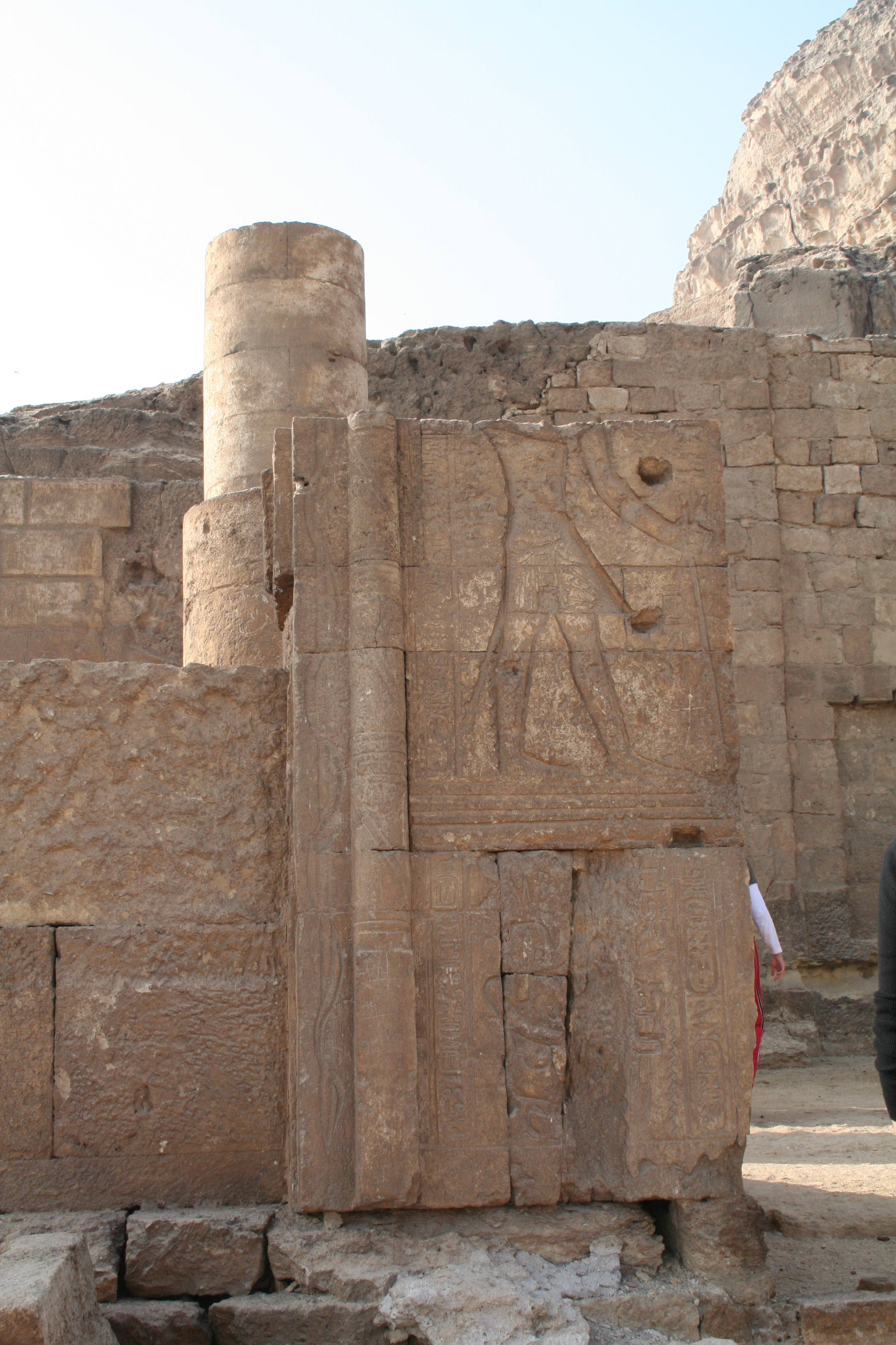
 The Temple of Amun (Akoris}
The site was settled since the Old Kingdom. It was an important administrative town in the 17th upper-Egyptian nome in all ancient Egyptian times. Maybe a Nile port belonged to the town. A lot of tombs were created in the rocks. They belonged to the officials of the Old Kingdom and the priests of the Late Period.
Archaeological remains came only from the New Kingdom and earlier times. In the New Kingdom the Temple of Amun was established in a former Old Kingdom tomb by Ramesses II and enlarged by Ramesses III. It is assumed that a fortress was established at this site in Persian times because of the strategic location of the town but no part of the fortress remains.
Akoris became an important town during the Greek and Roman periods, and its name was changed to Akoris. The today’s settlement traces came from the Roman and Coptic times.
Monuments at Akoris
Akoris is home to several archaeological sites, including a number of rock-cut tombs from the Old Kingdom period, known as Fraser Tombs (about 2 km south of Akoris). Akoris comprises also two temples from early Egyptian history (New Kingdom until the Roman period), a rock chapel (called rock chapel C), a Greek funeral chapel (formerly called “Roman temple”), two rock stelae of Ramesses III, a rock stele of Ptolemy V Epiphanes, a stele of Diana and the Gemini twins Castor and Pollux and a necropolis from the Greek and Roman periods. These monuments are scattered for about 3 km along the desert and the limestone rocks.
Gods at Akoris
The gods are related to the site location and shape of the rocks. The earliest goddess of this site is maybe a lion goddess. From the Fraser Tombs the goddess Hathor, mistress of the valley entrance, is known (time of Menkaura, 4th dynasty). Starting from the 18th dynasty the god Amun the foremost lion is adored. The god Sobek, Lord of Behet (Lord of the mouth of the desert path), was added at the 26. dynasty and became later the main god of the site. Other gods like Thoth, Isis and/or Mut, Osiris, Horus and Khonsu were adored from Greek-Roman times.
Mining
Like similar sites in the north and south of Akoris, this site was used as a limestone quarry in ancient times.
Excavations at Akoris
This site was firstly known from the Napoleon′s expedition. A more comprehensive investigation was made by the German expedition conducted by Karl Richard Lepsius in the 1850s. At the beginning of the 20th century further investigations were made by Ahmed Kamal and Gustave Lefebvre. Since 1981 new comprehensive excavations have been carried out by a Japanese team under H. Kawanishi. They uncovered a fine but fragmentary wooden boat model with many rowers of Middle Kingdom. Since 2002, they have investigated the southern part of the site and uncovered the TIP town.
The so-called Fraser Tombs were firstly discovered by the German Egyptologist Heinrich Brugsch in 1853 and firstly described by the British civil engineer George Willoughby Fraser half a century later.
Further reading
- Description de l’Égypte, Texte, vol. IV,pp. 372 – 377; Antiquités, vol. IV, plates 67.14–67.20.
- Karl Richard Lepsius, Denkmäler aus Aegypten und Aethiopien, Text vol. II, pp. 50–54; Tafeln Abth. 6, vol. XII, plates 75.15-75.23.
- Ahmed Kamal, Fouilles à Tehneh, in: Annales du Service des Antiquités de l’Égypte, vol. 4 (1903), pp. 232–241.
- Gustave Lefebvre, L. Barry, Rapport sur les fouilles exécutées à Tehnéh en 1903–1904, in: Annales du Service des Antiquités de l’Égypte, vol. 6 (1905), pp. 141–158, 2 plates.
- Labib Habachi, Three Large Rock-Stelae Carved by Ramesses III near Quarries. In: The Journal of the American Research Center in Egypt, ISSN 0065-9991, vol. 11 (1974), pp. 69 – 75, in particular pp. 71 – 73, plates 7 and 10.
- Rostislav Holthoer, Richard Ahlquist, The “Roman Temple” at Tehna el-Gebel, Helsinki, 1974, (Studia Orientalia Edidit Societas Orientalis Fennica ; 43,7), ISBN 951-95073-7-X.
- Dieter Kessler, Historische Topographie der Region zwischen Mallawi und Samaluṭ, Wiesbaden : Reichert, 1981, ISBN 978-3882260786, pp. 253 – 290.
- Paleological Association of Japan / Egyptian Committee, Akoris : report of the excavations at Akoris in Middle Egypt; 1981 – 1992, Kyoto, Koyo Shobo, 1995.
- Rosemarie Klemm, Dietrich D. Klemm, Stone and Stone Quarries in Ancient Egypt, London, British Museum Press, 2008, ISBN 978-0714123264 (Translation from the German Steine und Steinbrüche im alten Ägypten, Berlin, 1993)
- Kawanishi,H. et al., Preliminary Report AKORIS 1998-, Tsukuba, University of Tsukuba, 1999-, ISSN 1344-9893
External links
- "Tihna el-Gebel". EgyptSites. http://egyptsites.wordpress.com/2009/02/14/tihna-el-gebel/. Retrieved 2009-04-10.
- "Ṭihnā el-Gebel". Wikivoyage. http://www.wikivoyage.org/de/%E1%B9%ACihn%C4%81_el-Gebel. Retrieved 2009-04-10. − most comprehensive web resource
Categories:- Archaeological sites in Egypt
- Populated places in Egypt

Wikimedia Foundation. 2010.