- Świdnik County
Infobox Settlement
name = Świdnik County
native_name = Powiat świdnicki
settlement_type =_flag.png)
image_shield = POL powiat świdnicki COA.svg
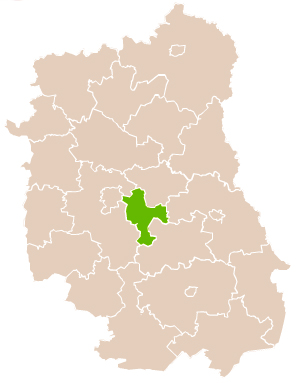
map_caption = Location within the voivodeship
subdivision_type = Country
subdivision_name = POL
subdivision_type1 = Voivodeship
subdivision_name1 = Lublin
area_total_km2 = 468.97
population_total = 72290
population_as_of = 2006
population_density_km2 = auto
population_urban = 42663
population_blank1_title = Rural
population_blank1 = 29627
coor_type = Świdnik
latd = 51
latm = 13
lats =
latNS = N
longd = 22
longm = 42
longs =
longEW = E
seat =Świdnik
parts_type =Gmina s
parts = Total 5 (incl. 1 urban)
p1 =Świdnik
p2 =Gmina Mełgiew
p3 = Gmina Piaski
p4 =Gmina Rybczewice
p5 =Gmina Trawniki
blank_name = Car plates
blank_info = LSW
website = http://www.starostwo.swidnik.pl/ __NOTOC__Świdnik County ( _pl. powiat świdnicki) is a unit of territorial administration and local government (powiat ) inLublin Voivodeship , easternPoland . It was created onJanuary 1 ,1999 as a result of the Local Government Reorganization Act of 1998. Its administrative seat and largest town isŚwidnik , which lies convert|10|km|mi|0 east of the regional capitalLublin . The only other town in the county isPiaski , lying convert|14|km|mi|0|abbr=on south-east of Świdnik.The county covers an area of convert|468.97|km2|sqmi|1. As of 2006 its total population is 72,290, out of which the population of Świdnik is 40,037, that of Piaski is 2,626, and the rural population is 29,627.
Neighbouring counties
Świdnik County is bordered by
Łęczna County to the north-east,Chełm County to the east,Krasnystaw County to the south-east, andLublin County and the city ofLublin to the west.Administrative division
The county is subdivided into five
gmina s (one urban, one urban-rural and three rural). These are listed in the following table, in descending order of population.References
* [http://www.stat.gov.pl/gus/45_655_PLK_HTML.htm Polish official population figures 2006]
_flag.svg)
Wikimedia Foundation. 2010.