- Big Thompson River
Geobox River
name = Big Thompson River
native_name =
other_name =
image_size = 300
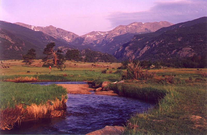
image_caption = The headwaters of the Big Thompson River are in Rocky Mountain National Park.
etymology =
country = United States
country1 =
state = Colorado
state1 =
region_type =
region =
region1 =
city = Loveland
city1 =
landmark =
landmark1 =
length_imperial = 78
length_note = [http://www.bartleby.com/69/38/B06238.html Big Thompson River] , The Columbia Gazetteer of North America. 2000.]
watershed_imperial =
watershed_round =
watershed_note =
discharge_location =Loveland
discharge_imperial = 72.5
discharge_max_imperial = 4240
discharge_min_imperial = 0.48
discharge_round = 2
discharge_note = [http://pubs.usgs.gov/wdr/wdr-co-03-1/vol1/pdf/WDR_CO-03-1.pdf Water Data Report, Colorado 2003] , from [http://pubs.usgs.gov/wdr/wdr-co-03-1/ Water Resources Data Colorado Water Year 2003] , USGS.]
discharge1_location =
discharge1_imperial =
source_name = Rocky Mountains
source_location =
source_district =
source_region =
source_state =
source_country =
source_lat_d = 40
source_lat_m = 25
source_lat_s = 41
source_lat_NS = N
source_long_d = 105
source_long_m = 47
source_long_s = 29
source_long_EW = W
source_coordinates_note = Gnis|205019|Big Thompson River, USGS GNIS.]
source_elevation_imperial = 11310
source_elevation_note =Google Earth elevation for GNIS coordinates.]
source_length_imperial =
mouth_name = South Platte River
mouth_location = Near Greeley
mouth_district =
mouth_region =
mouth_state =
mouth_country =
mouth_lat_d = 40
mouth_lat_m = 21
mouth_lat_s = 16
mouth_lat_NS = N
mouth_long_d = 104
mouth_long_m = 45
mouth_long_s = 37
mouth_long_EW = WThe headwaters of the river begin in Forest Canyon within
Rocky Mountain National Park inLarimer County, Colorado . The river flows east, through Moraine Park to the town of Estes Park. There it is held in Lake Estes by the Olympus Dam before being released into theBig Thompson Canyon . The North Fork of the Big Thompson River also begins in Rocky Mountain National Park, on the northern slopes of theMummy Range . This tributary flows east, through the town of Glen Haven where it merges with the Big Thompson River in the town of Drake in the Big Thompson Canyon.From Lake Estes, the River descends 1/2 mile (800 m) in elevation through the mountains in the spectacular 25 mi. (40 km) Big Thompson Canyon, emerging from the foothills west of Loveland. It flows eastward, south of Loveland across the plains into Weld County and joins the South Platte approximately 5 mi (8 km) south of Greeley. It receives the
Little Thompson River approximately 4 mi (6 km) upstream from its mouth.Water resources in the Big Thompson River are managed by the
Northern Colorado Water Conservancy District as part of theColorado-Big Thompson Project .Big Thompson Canyon Flooding of 1976
On
July 31 ,1976 , during the celebration of Colorado's centennial, the Big Thompson Canyon was the site of devastatingflash flood s that swept down the steep and narrow canyon, claiming the lives of 143 people, 5 of whom were never found. This flood was triggered by a nearly stationarythunderstorm near the upper section of the canyon that dumped 30 centimeters (12 inches) of rain in less than 4 hours (more than 3/4 of the annual rainfall for the area). Little rain fell over the lower section of the canyon, where many of the victims were. Around 9PM a wall of water more than 6 meters (20 ft) high raced down the canyon at about 6 m/s (14 mph), destroying 400 cars, 418 houses and 52 businesses and washing out most ofU.S. Route 34 . [D. Hyndman and D. Hyndman, "Natural Hazards and Disasters" (Thomson Brooks/Cole, 2006), 270-271.]This flood was more than 4 times as strong as any in the 112-year record available in 1976, with a discharge of 1,000 cubic meters per second (30,000 ft³/s). However, paleoflood data obtained from
radiocarbon dating of sediments indicates that such flooding occurs in the area every few thousand years.In 2008, a man who was thought to have died in the flood was found to be alive and living in Oklahoma. Darrell Johnson and his family had rented a cabin in Estes Park, but left without telling anyone on the morning of July 31. A woman who was researching the flood's victims discovered he was still alive. [ [http://www.thedenverchannel.com/news/17063297/detail.html Flood 'Victim' Found Alive 32 Years Later] , TheDenverChannel.com. 2008.]
ee also
*
List of Colorado rivers
*Colorado-Big Thompson Project References
External links
* [http://www.idreamof.com/disaster/vic_btc.html I Dream of Genealogy Memorial for Big Thompson Canyon Flood Victims of 1976]
* [http://www.noaanews.noaa.gov/stories/s688.htm NOAA Site on the Big Thompson Canyon Floods]* [http://www.ids.colostate.edu/index.html?/projects/bigt Colorado State University: Big Thompson Watershed]
* [http://www.ncwcd.org/ Northern Colorado Water Conservancy District]
* [http://www.larimerco.com/5visitors/51004big_thompson.htm Larimer County website: History of the flood]mouth_coordinates_note =
mouth_elevation_imperial = 4670
mouth_elevation_note =
tributary_left = North Fork Big Thompson River
tributary_left1 =
tributary_right = Little Thompson River
tributary_right1 =
free_name =
free_value =
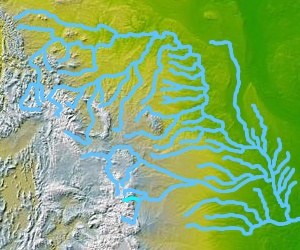
map_size = 300
map_caption = Big Thompson River highlighted in lower center of map.The Big Thompson River is atributary of theSouth Platte River , approximately 78 miles (123 km) long, in theU.S. state ofColorado .
Wikimedia Foundation. 2010.