Orongorongo River

Orongorongo River
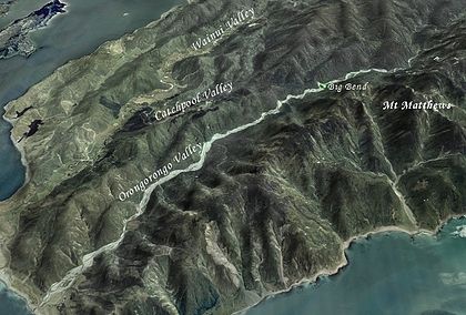
Aerial view of the Orongorongo Valley

The Orongorongo River runs southwest through the Orongorongo Valley in the southern Rimutaka Ranges of the North Island of New Zealand. The river and its associated catchments lie within the bounds of the Rimutaka forest park, which is administered by the Department of Conservation (New Zealand)[1]

For much of its course the river is a braided river, with a wide bed of gravel and a number of streams of water. The gravel bed can be seen as light-coloured areas of varying width in the image to the right.

References

  1. ^ http://www.doc.govt.nz/templates/PlaceProfile.aspx?id=35041 accessed on the 18th of March 2007

External links

Coordinates: 41°25′S 174°54′E / 41.417°S 174.9°E / -41.417; 174.9


Wikimedia Foundation. 2010.

Игры ⚽ Нужно сделать НИР?

Look at other dictionaries:

  • Wainuiomata River — The Wainuiomata River runs southwest through the Wainuiomata Valley located in the southern Rimutaka Ranges in the North Island, New Zealand.Origin of NameThe word Wainui o mata is a Māori name made up of the words Wai = water, Nui = big, O = of …   Wikipedia

  • List of rivers of New Zealand — This is a list of all waterways named as rivers in New Zealand. In a small number of cases, which have not been fully indexed here, there are multiple rivers bearing the same name; in these cases the notation (#) indicates the number of rivers… …   Wikipedia

  • Liste der Flüsse in Neuseeland — Die Liste der Flüsse in Neuseeland gibt eine Übersicht über alle permanent wasserführenden Flüsse im Staat Neuseeland: Inhaltsverzeichnis A B C D E F G H I J K L M N O P Q R S T U V W X Y Z …   Deutsch Wikipedia

  • Liste des cours d'eau de Nouvelle-Zélande — Liste des cours d eau de Nouvelle Zélande. Pour un petit nombre de cas, qui n a pas été pris intégralement en compte ici, il existe de multiples rivières portant un nom identique. Dans ce cas, la notation (#) indique le nombre de rivières… …   Wikipédia en Français

  • Liste des rivières de Nouvelle-Zélande — Liste des cours d eau de Nouvelle Zélande Liste des cours d eau de Nouvelle Zélande. Pour un petit nombre de cas, qui n a pas été pris intégralement en compte ici, il existe de multiples rivières portant un nom identique. Dans ce cas, la notation …   Wikipédia en Français

  • Brachyglottis greyi — Taxobox image width = 240px image caption = Daisy bush regnum = Plantae divisio = Magnoliophyta classis = Magnoliopsida ordo = Asterales familia = Asteraceae tribus = Senecioneae genus = Brachyglottis species = B. greyi binomial = Brachyglottis… …   Wikipedia

  • Mount Matthews — The Wellington Region, where Mount Matthews is located. Mount Matthews is the highest peak in the Rimutaka Ranges to the east of Wellington Harbour and the Wellington Region in general. Mt Matthews reaches a height of 940 metres and although not… …   Wikipedia

  • Mount Matthews — Nordinsel Neuseelands mit Lage der Rimutaka Range Höhe …   Deutsch Wikipedia

  • Common Brushtail Possum — Common Brushtail Possum[1] Common brushtail possums at Austins Ferry, Tasmania, Australia Conservation status …   Wikipedia

  • Wainuiomata — is a suburban town located within the city limits of Lower Hutt and part of the Wellington urban area in the lower North Island of New Zealand. It is located six kilometres to the southeast of the Lower Hutt CBD, and has a population of around 16 …   Wikipedia

Share the article and excerpts

Direct link
Do a right-click on the link above
and select “Copy Link”