- Snake Range
Geobox|Range
name=Snake Range
image_size=300
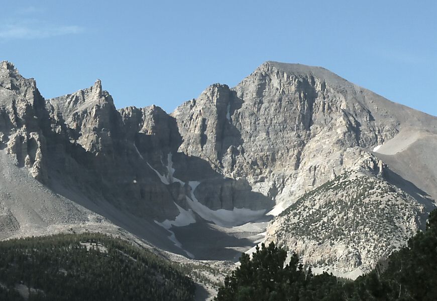
image_caption=Wheeler Peak looking southwest from Maheur Viewpoint
country=United States
state=Nevada
parent= | border=Schell Creek Range| border1=Confusion Range
length_imperial=60
length_orientation=North-South
highest=Wheeler Peak
highest_elevation_imperial=13063
highest_lat_d=38|highest_lat_m=59|highest_lat_s=09|highest_lat_NS=N
highest_long_d=114|highest_long_m=18|highest_long_s=50|highest_long_EW=W
geology=| geology1=
period=
orogeny=
map_size=200
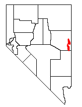
map_caption=Location of the Snake Range within NevadaThe Snake Range is a line of high mountains in eastern White Pine County, in east-central
Nevada in the westernUnited States . Typical of other ranges in theBasin and Range Province , it runs in a north-south direction, in this case for approximately convert|60|mi|km|0. To the west are Spring Valley and theSchell Creek Range , while to the east are the border withUtah , the Snake Valley, and theConfusion Range .The Snake Range includes two groups of peaks. The southern section rises quickly from a point near the border with Lincoln County, reaching the summit of Granite Peak (11,218 ft, 3419 m) just 10 miles (16 km) to the north. From there the range continues to rise, passing Lincoln Peak (11,597 ft, 3535 m), Mt. Washington (11,658 ft, 3553 m), Pyramid Peak (11,926 ft, 3635 m), Baker Peak (12,298 ft, 3748 m), Jeff Davis Peak (12,771 ft, 3893 m), and finally reaching its apex at Wheeler Peak (13,063 ft, 3982 m). This area also includes the 83-foot (25 m) span of Lexington Arch, and
Lehman Caves , both cut into limestone. Several large groves ofGreat Basin Bristlecone Pine s thrive in this region.In 1986 this southern section of the range was selected as the location of the
Great Basin National Park , recognizing both the unique geologic features of these mountains as well as their representation of the region as a whole.From Wheeler Peak the range begins to drop, reaching convert|7154|ft|m|0 at Sacramento Pass, just 11 miles to the north. Here is where
U.S. Route 50 , the "Loneliest Highway in America", crosses the range, and provides the principal means of access to this area of eastern Nevada.Sacramento Pass is also where the more remote northern section of the range begins. In just 12 miles (19 km) it rises past Silver Creek and Hendrys Creek Canyons to the summit of photogenic Mt. Moriah (12,067 ft, 3678 m). To the north of this peak is an unusual formation, a flat surface of sub-alpine
tundra called "The Table", covering about 2 square miles and lying at an elevation of 11,000 feet (3350 m). Nestled on this surface near the mountain is a grove of ancient Bristlecone Pines.North of 'The Table' is yet another unusual geologic feature. Deadman Creek and Smith Creek, draining eastward into Snake Valley, combine to carve a deep canyon into the range. The mouth of this canyon lies below 3000-foot cliffs, 6000 feet below (and just 6 miles away from) the summit of Mt. Moriah. The higher elevations of this northern section of the Snake Range is protected as the Mt. Moriah Wilderness Area, and the southern portion of the Range is protected as the
Highland Ridge Wilderness .External links
* [http://www.peakbagger.com/range.aspx?rid=13338 Peakbagger.com (Snake Range)]
* [http://www.summitpost.org/object_list.php?object_type=0&object_name_0=moriah&page=1 Summitpost.org (Mt. Moriah)]
Wikimedia Foundation. 2010.