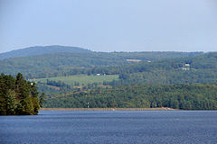
- Moore Reservoir
-
Moore Reservoir Location Grafton County and Coos County, New Hampshire; Caledonia County and Essex County, Vermont Coordinates 44°20′6″N 71°52′32″W / 44.335°N 71.87556°WCoordinates: 44°20′6″N 71°52′32″W / 44.335°N 71.87556°W Lake type Reservoir Primary inflows Connecticut River Primary outflows Connecticut River Basin countries United States Max. length 9.8 mi (15.8 km) Max. width 2.0 mi (3.2 km) Surface area 3,490 acres (14.1 km2) Surface elevation 806 ft (246 m) Settlements Littleton and Dalton, New Hampshire; Waterford and Concord, Vermont Moore Reservoir is an impoundment on the Connecticut River located in the communities of Littleton, New Hampshire; Dalton, New Hampshire; Waterford, Vermont; and Concord, Vermont. It occupies approximately 3,490 acres (14.1 km2). It was created by the completion of the Moore Dam in 1956, which caused the flooding of several villages, including Pattenville, New Hampshire, and old Waterford, Vermont.[1]
References
- ^ The Columbia Gazetteer of North America, 2000.
Categories:- Reservoirs in New Hampshire
- Reservoirs in Vermont
- Concord, Vermont
- Waterford, Vermont
- Landforms of Coos County, New Hampshire
- Landforms of Grafton County, New Hampshire
- Geography of Caledonia County, Vermont
- Geography of Essex County, Vermont
- New Hampshire geography stubs
- Vermont geography stubs
Wikimedia Foundation. 2010.

