- Province of Pomerania
Infobox Former Subdivision
common_name = Pomerania
conventional_long_name = Pomerania
native_name = "Pommern"
subdivision = Province
nation = Prussia

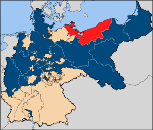
image_map_caption = Pomerania (red), within theKingdom of Prussia , within theGerman Empire
capital = Stettin
latd=53|latm=26|latNS=N|longd=14|longm=32|longEW=E
stat_area1= 30120
stat_pop1 = 1684125
stat_year1 = 1905
p1 = Swedish Pomerania
flag_p1 = Naval Ensign of Sweden.svg
p2 = Farther Pomerania
image_p2 =
s1 = Mecklenburg-Western Pomerania
flag_s1 = Flag of Mecklenburg-Western Pomerania (state).svg
s2 = Szczecin Voivodeship
flag_s2 =
year_start = 1815
year_end = 1946
political_subdiv = Köslin
Stettin
Posen-West Prussia
Stralsund:"For the present-day Polish provinces, see
Pomeranian Voivodeship andWest Pomeranian Voivodeship . For the present-day German state, seeMecklenburg-Vorpommern ."The Province of Pomerania ( _de. Provinz Pommern) was a province of the
Kingdom of Prussia and theFree State of Prussia from 1815 until 1946. It was created fromFarther Pomerania andSwedish Pomerania ("Hither" or "Western Pomerania "), which were created from the Duchy of Pomerania after thePeace of Westphalia in 1648 and had belonged toBrandenburg-Prussia andSweden , respectively. Sweden had awarded her part of Pomerania toDenmark by theTreaty of Kiel in 1814, but the treaty never entered into force and the territory was passed to Prussia by theCongress of Vienna the following year.The province was subdivided into the superior administrative districts (
Regierungsbezirk ) Köslin (Eastern part, "Farther Pomerania"), Stettin (Southwestern part, "Altvorpommern"), Stralsund (Northwestern part, "Neuvorpommern"; merged into Stettin in October 1, 1932), and Grenzmark Posen-Westpreußen (Southeastern part, created from the former Prussian provinceGrenzmark Posen-Westpreußen when it was merged into Pomerania in October 1, 1938). The Province's capital wasStettin ("now Szczecin"), the "Regierungsbezirk" capitals wereKöslin ("now Koszalin"), Stettin,Stralsund andSchneidemühl ("now Pila"), respectively.After
World War II , Pomerania was part of theSoviet occupation zone . The section of Pomerania east of theOder-Neisse line was ceded to Poland and resettled with Poles after the German population was expelled. The territory west of the Oder-Neisse line became part of the East Germany in 1949 and was merged withMecklenburg to form the new state ofMecklenburg-Vorpommern .Population
In 1905, of 1,684,326 inhabitants 1,616,550 were
Protestants , 50,206Roman Catholics and 9660Jews , (1900) 14,162 Polish speakers (at theWest Prussia n border) and 310Kashubian speakers (at the LakesLebasee andGardescher See ). [Meyers Konversations Lexikon 1905, online at [http://www.zeno.org/Meyers-1905/A/Pommern?hl=pommern] ]Köslin government region (Farther Pomerania)
The Köslin government region ("Regierungsbezirk Köslin") was the administrative name for the region of
Farther Pomerania ("Hinterpommern") along with the smaller region ofLauenburg and Bütow Land (easternmost part).These parts of Pomerania were integrated into Prussia ("
Brandenburg-Prussia ") after thePeace of Westphalia ended theThirty Years' War in 1648. During the war, the nobleHouse of Pomerania ("Griffins"), ruling Pomerania since the 1120s as Dukes of Pomerania, went extinct in the male line with the death of Bogislaw XIV in 1637. Throughout the existence of the Griffin duchy, Brandenburg claimed overlordship and was asserted of Pomerania inheritance in numerous treaties. Yet,Sweden had been one of the most important players in the war and as such, she was awarded some of her territorial gains in Pomerania after the war by the Peace of Westphalia, thwartening Brandenburg-Prussia's ambitions for inheritance of the whole former Duchy of Pomerania. This led to tensions between Brandenburg-Prussia and Sweden in Pomerania until Sweden lost herWestern Pomerania n possessions in 1720 and 1815.Landkreis Lauenburg-Bütow comprised theLauenburg and Bütow Land , aPomerelia n borderland with a somewhat different history than the rest of Pomerania. It was in 1846 dissolved into smaller administrative units. In contrast to ethnic German Pomerania, this area also had a Kashubian population.Landkreis Fürstenthum comprised the earlier secular possessions of theRoman Catholic Diocese of Kammin bishops, ruled by Pomeranian dukes after theReformation . Until 1872, the area kept its territorial integrity, before it was dissolved into smaller administrative units.During
World War II , Farther Pomerania became a battlefield and was occupied by theRed Army in early 1945. While thePomeranian Offensive took place in the East, the advances in the course of theBattle of Berlin cut Farther Pomerania off the West and only left a short-lived pocket aroundKolberg . The population was evacuted via theBaltic Sea from the Kolberg port, until Kolberg, which was declared a fortress, surrendered. By the terms of thePotsdam agreement , Farther Pomerania became part ofPoland . The remaining German population was expelled and the area was resettled with Poles.Administrative subdivision
*urban districts (Stadtkreis):
**Stolp : population 27.293 (1900); 50.377 (1939)
**Köslin : split off Landkreis Köslin in 1923, population 33.479 (1939)
**Kolberg : split off Landkreis Kolberg-Körlin in1920, population 36.617 (1939)*rural districts (Landkreis):
**Landkreis Belgard (Persante) : population 47.097 (1900); 79.183 (1939)
**Landkreis Dramburg : population 35.863 (1900);
**Landkreis Fürstenthum (1816-1872), 1872 divided into
***Landkreis Bublitz : population 20.916 (1900); in 1932 merged into Landkreis Köslin
***Landkreis Kolberg-Körlin : population 57.871 (1900); 38.785 (1939)
***Landkreis Köslin : population population 48.678 (1900); 80.287 (1939)
**Landkreis Greifenberg i. Pom. : until 1939 administered by Regierungsbezirk Stettin, population 47.891 (1939)
**Landkreis Lauenburg-Bütow (theLauenburg and Bütow Land ), 1846 divided into:
***Landkreis Bütow : population 26.021 (1900); 28.018 (1939)
***Landkreis Lauenburg i. Pom. : population 45.986 (1900); 63.985 (1939)
**Landkreis Neustettin : population 76.101 (1900); since 1938 administered by Regierungsbezirk Grenzmark Posen-Westpreußen
** Regenwalde: 49.668 (1939), until 1938 administered by Regierungsbezirk Stettin
**Landkreis Rummelsburg i. Pom. : population 33.785 (1900); 40.692 (1939)
**Landkreis Schivelbein : population 19.656 (1900); in 1932 merged into Landkreis Belgard (Persante)
**Landkreis Schlawe i. Pom. : population 73.206 (1900); 78.363 (1939)
**Landkreis Stolp : population 75.310 (1900); 83.009 (1939)Stettin government region (Western Pomerania)
The Stettin government region ("Regierungsbezirk Stettin") comprised the region of
Western Pomerania ("Vorpommern", "Hither Pomerania"), the formerSwedish Pomerania .The area was held by
Sweden after theThirty Years' War , when Sweden had occupied all of the former Duchy of Pomerania in 1631. In theTreaty of Stettin (1630) , a treaty about an alliance between the last Pomeranian duke Bogislaw XIV and the Swedish king Gustavus (II) Adolphus, Bogislaw acknowledged Swedish succession over his duchy despite century-old Brandenburg claims. In the 1648Peace of Westphalia , Western Pomarania officially became a part of Sweden. Brandenburg-Prussia succeeded in taking over Swedish Pomerania during theSwedish-Brandenburgian War (1674–1679, a war arisen between Brandenburg and Sweden being enemy parties in the contemporaryFranco-Dutch War ), yet in thePeace of Saint-Germain (1679) , Sweden regained Western Pomerania except some areas on the right bank of theOder River, which had been agreed to hand over to Brandenburg already in a 1653 border revision. This temptedFrederick William, Elector of Brandenburg , to utter "Exoriare aliquis nostris ex ossibus ultor!" [Büchmann, Geflügelte Worte] .In 1711, Brandenburg-Prussia invaded Swedish Pomerania in the course of the
Great Northern War (1700-1721). The 1720 Treaty of Stockholm left Western Pomerania south of thePeene River ("Altvorpommern") with Brandenburg-Prussia, only parts of north of the Peene River ("Neuvorpommern") were restored to Sweden after they had been occupied byDenmark .In the 1814
Peace of Kiel , Sweden offered "Neuvorpommern" toDenmark to compensate her forNorway that had been subdued in an 1813 Swedish campaign. In the 1815Congress of Vienna , Brandenburg-Prussia took over this claim and integrated "Neuvorpommern" in her Pomeranian province, Denmark in turn was awarded theDuchy of Lauenburg and freed of her war reparations to Sweden resulting from the Kiel treaty, that she was unable to pay, these were now paid by Prussia. "Neuvorpommern" was administered as Regierungsbezirk Stralsund until it was merged into Regierungsbezirk Stettin in 1932.Stettin, the former ducal residence, was made capital of the province and also was the administrative center of the Regierungsbezirk Stettin.
During
World War II , Pomerania became a battlefield and was occupied by theRed Army after the Soviet advances in the course of theBattle of Berlin . By the terms of thePotsdam agreement , Western Pomerania east of theOder-Neisse line became part ofPoland . This line left theOder river north ofGartz (Oder) and included theStettin andSwinemünde area ("Stettiner Zipfel") into the Polish state. The remaining German population was expelled and the area was resettled with Poles. Western Pomerania west of the Oder-Neisse line was merged withMecklenburg to constitute the state ofMecklenburg-Vorpommern in theSoviet Occupation Zone of Germany, that in 1949 became theGerman Democratic Republic (GDR). "Vorpommern" was soon dropped from the federal state's name, and after the GDR states were abolished, the coastal Western Pomeranian Landkreis districts became part ofBezirk Rostock whereas the mainland Landkreis districts became part ofBezirk Neubrandenburg .In 1990, after the GDR communist system was overthrown, the state of
Mecklenburg-Vorpommern was recreated, with Vorpommern being a non-administrative region. The old Landkreis districts were fused into five larger districts: Rügen,Nordvorpommern ,Ostvorpommern , Uecker-Randow and Demmin, whith the latter also containingMecklenburg ian Landkreis districts. Due to this and slight Landkreis border changes during the GDR period, the old Pomeranian border disappeared from the map and today is only prevailed by the border of thePomeranian Evangelical Church .Administrative subdivision
*urban districts (Stadtkreis):
**Greifswald : until 1932 administered by Regierungsbezirk Stralsund, population 37.051 (1939)
**Stargard (Pommern) : split off Landkreis Saatzig in 1901, population 39.760 (1939)
**Stettin : population 210.702 (1900); 382.984 (1939)
**Stralsund : until 1932 administered by Regierungsbezirk Stralsund, population 52.931 (1939)*rural districts (Landkreis):
**Landkreis Anklam : population 32.693 (1900); 39.527 (1939)
**Landkreis Cammin i. Pom. : population 42.485 (1900); 45.694 (1939)
**Landkreis Demmin : population 48.090 (1900); 54.769 (1939)
**Landkreis Franzburg-Barth (Capital:Barth ): until 1932 administered by Regierungsbezirk Stralsund, population 55.542 (1939)
**Landkreis Greifenberg i. Pom. : population 37.483 (1900); after 1939 administered by Regierungsbezirk Köslin
**Landkreis Greifenhagen : population 48.258 (1900); 69.326 (1939)
**Landkreis Greifswald : until 1932 administered by Regierungsbezirk Stralsund, population 39.207 (1939)
**Landkreis Grimmen : until 1932 administered by Regierungsbezirk Stralsund, population 42.259 (1939)
**Landkreis Naugard : population 52.777 (1900); 61.320 (1939)
**Landkreis Pyritz : population 42.686 (1900); 48.418 (1939)
**Landkreis Randow : population 94.859 (1900); partitioned in 1939 by Stadtkreis Stettin, Landkreis Greifenhagen, Landkreis Ueckermünde, and Landkreis Naugard
**Landkreis Rügen (Capital:Bergen auf Rügen ): until 1932 administered by Regierungsbezirk Stralsund, population 62.261 (1939)
**Landkreis Regenwalde : population 44.954 (1900);
**Landkreis Saatzig (Capital:Stargard (Pommern) ): population 69.762 (1900); 43.258 (1939)
**Landkreis Ueckermünde : population 56.767 (1900); 79.996 (1939)
**Landkreis Usedom-Wollin (Capital:Swinemünde ): population 52.193 (1900); 83. 479 (1939)Stralsund government region (Northwest)
The Stralsund government region ("Regierungsbezirk Stralsund") comprised the
Western Pomerania n region of "Neuvorpommern".The reason for creating a Regierungsbezirk as small as Stralsund was that Neuvorpommern had a somewhat different history than the rest of Pomerania. This region, consisting of the island of
Rügen and the adjacted mainland between theRecknitz andPeene rivers, made up the Rani and DanishPrincipality of Rugia in theMiddle ages . Although it was inherited by the Pomeranian dukes in 1325, the region was for some time goverened as the splinter duchy of Pomerania-Barth. While a part ofSwedish Pomerania ,Denmark maintained her old claims and occupied the area in 1715 during theGreat Northern War . Yet, the Danes were forced to return it to Sweden by the 1720Treaty of Stockholm (Great Northern War) . In the 1813Treaty of Kiel , Denmark again gained nominal overlordship, yet was unable to pay her war reparations to Sweden and awarded her claim toPrussia in the 1815Congress of Vienna along with her debts in exchange for theDuchy of Lauenburg .The name "Neuvorpommern" ("New Western Pomerania") originates in that era, to distinguish the Western Pomeranian areas south of the Peene River gained by Prussia in 1720 ("Altvorpommern", "Old Western Pomerania") from the northern regions gained in 1815 and to replace the outdated term "Principality of Rugia".
Regierungsbezirk Stralsund was fused into Regierungsbezirk Stettin in 1932.
Administrative subdivision
*urban districts (Stadtkreis):
**Stralsund : split off Landkreis Franzburg-Barth in 1874, population 31.076 (1900)
**Greifswald : split off Landkreis Greifswald in 1913*rural districts (Landkreis):
**Landkreis Franzburg-Barth : population 41.704 (1900)
**Landkreis Greifswald : population 61.840 (1900)
**Landkreis Grimmen : population 35.540 (1900)
**Landkreis Rügen (capitalBergen auf Rügen ): population 46.270 (1900)Posen-West Prussia government region
The Posen-West Prussia government region ("Regierungsbezirk Grenzmark Posen-Westpreußen") was created of the northern part (Schneidemühl government region) of the former Prussian province
Posen-West-Prussia .Following
World War I , most of the Prussian provinces Posen andWest Prussia became part of reconstitutedPoland . The remainders of these provinces formed the province of Posen-West Prussia, combining small German-settled regions all along the new German-Polish border ("Grenzmark" meaning "border march"). In 1938, this province was dissolved and partitioned between Pomerania, Brandenburg and Silesia. The Pomeranian share was extended by Landkreis Neustettin, formally administered by Regierungsbezirk Stettin.During
World War II , it became a battlefield and was occupied by theRed Army in early 1945. By the terms of thePotsdam agreement , the Grenzmark became part ofPoland . The German population was expelled and the area was resettled with Poles.Administrative subdivision
*urban districts (Stadtkreis):
**Schneidemühl *rural districts (Landkreis):
**Landkreis Arnswalde
**Landkreis Deutsch Krone
**Landkreis Dramburg
**Landkreis Flatow
**Landkreis Friedeberg Nm.
**Netzekreis (capital:Schönlanke )
**Landkreis Neustettin
**Landkreis Schlochau See also
*
Pomerania
*Farther Pomerania
*Western Pomerania
*Provinces of Prussia References
External links
* [http://www.gemeindeverzeichnis.de/gem1900//gem1900.htm?pommern/pommern1900.htm Gemeindeverzeichnis Deutschland 1900] de icon


Wikimedia Foundation. 2010.