Sennaya Square

Sennaya Square

Coordinates: 59°55′37″N 30°19′05″E / 59.927°N 30.318°E / 59.927; 30.318

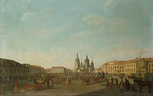
Vintage view of Sennaya Square.

Sennaya Square or Sennaya Ploshchad (Russian: Сенная Площадь, literally: Hay Square), known as Peace Square between 1963 and 1991, is a large city square in Central Saint Petersburg, located at the crossing of Garden Street, Moskovsky Prospekt, and Grivtsova Lane.

The square was established in 1737, and was a market where hay, firewood, cattle were sold. It was built under the extension of the Garden Street, and grew quickly, becoming the cheapest and the most active market in Saint Petersburg. The Hay Market was a place where merchants and farmers could trade. It was there that malefactors were flogged before a large concourse of people.

In 1753, the Church of the Assumption of the Mother of God was built in a sumptuous Baroque style. In the middle of the square is a former guardhouse (1818-20). The square was a venue for the cholera riots of 1831. The surrounding district was known for its infamous slums, which provide the setting for Dostoevsky's novel Crime and Punishment.

In 1961 the church was pulled down to make place for a new metro station. Its place is now marked by a chapel. The 17,5 meter high "Peace Column", a gift of France to the tercentenary of St. Petersburg, was dismantled during the heatwave of 2010. The column featured the word "peace" written in 49 languages.

The square is served by three metro stations; Sennaya Ploshchad, Sadovaya and Spasskaya. It is also a bus and marshrutka station. It used to have regular tram transportation until 2010, a fragment of the tram rails having been preserved as a historical mark.

External links


Wikimedia Foundation. 2010.

Игры ⚽ Поможем решить контрольную работу

Look at other dictionaries:

  • Central Saint Petersburg — See also: Historic Centre of Saint Petersburg and Related Groups of Monuments The Nevsky Prospekt …   Wikipedia

  • Gorokhovaya Street — ( ru. Гороховая улица) is a north south thoroughfare in the Central Business District of Saint Petersburg.Gorokhovaya Street extends from the Admiralty and runs south, crossing the Moyka River and the Griboyedov Canal, crossing the Garden Street… …   Wikipedia

  • Сенная площадь (Санкт-Петербург) — Эту страницу предлагается переименовать. Пояснение причин и обсуждение  на странице Википедия:К переименованию/1 июня 2012. Возможно, её текущее название не соответствует нормам современного русского языка и/или правилам именования статей… …   Википедия

  • Monument to Nicholas I — Russian: Памятник Николаю I Current state (2004) Location St Isaac s Square in Saint Petersburg, Russia Designer …   Wikipedia

  • Moskovsky Prospekt — Coordinates: 59°53′09″N 30°19′11″E / 59.8859°N 30.3197°E / 59.8859; 30.3197 …   Wikipedia

  • Nizhny Novgorod — For other cities named Novgorod, see Novgorod (disambiguation). Nizhny Novgorod (English) Нижний Новгород (Russian) …   Wikipedia

  • Landmarks of Saint Petersburg — help to give the city its particular ambience.St. Petersburg s position below the Arctic Circle, on the same latitude as nearby Helsinki, Stockholm, Aberdeen and Oslo (60° N), causes twilight to last all night in May, June and July. This… …   Wikipedia

  • M10 highway (Russia) — M10 Federal Highway M10 Федеральная автомобильная дорога M10 Russia–Scandinavia Highway …   Wikipedia

  • Mologa — Coordinates: 58°11.98′N 38°26.47′E / 58.19967°N 38.44117°E / 58.19967; 38.44117 …   Wikipedia

  • Cholera Riots — Contents 1 Cholera Riots in Russia 2 Cholera Riots in Great Britain 3 Cholera Riots in Germany 4 Cholera Riots in Zimbabwe …   Wikipedia

Share the article and excerpts

Direct link
Do a right-click on the link above
and select “Copy Link”