- Watford Gap
-
This article is about Watford Gap, a geographical location. For the larger town 80 km (50 mi) south, see Watford. For the nearby village, see Watford, Northamptonshire.

The Watford Gap is located at a minor gap between two slight hills in the county of Northamptonshire, England. Engineers from Roman times onwards have found it to be an appropriate route connecting the Midlands with the South East.
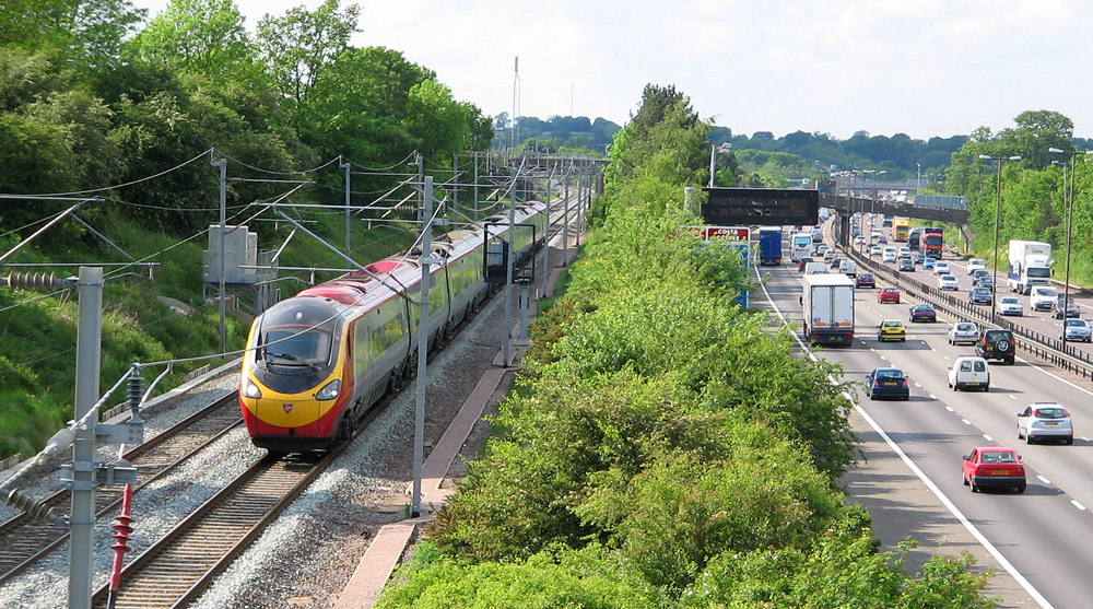
In a width of 400 metres (0.25 mi) the A5 road, the West Coast Main Line railway, the M1 motorway and a branch of the Grand Union Canal all traverse the gap in parallel.
Contents
Focal point
An easy route between the London and Birmingham areas passes through or close to the small village of Watford, Northamptonshire, located near Daventry and Long Buckby. In the era of Roman Britain, the Watling Street Roman road, an important route from SE to NW, utilised the gap. This road developed into the A5 trunk route.
Later the road was joined by the Leicester Arm of the Grand Union Canal. Just to the north of the Gap, this canal passes through the Watford Locks.
The historical geographic importance of the area led to many modern communication routes passing through this narrow gap: the coming of the railways brought the London and Birmingham Railway linking London to Birmingham and later on to Manchester, Liverpool and Glasgow. This is known today as the West Coast Main Line. The most recent addition, in 1959, was the M1, Britain's first inter-urban motorway which links London and Yorkshire; together with the first motorway service station.
Nevertheless the proposed route of the HS2 high speed railway line does not pass through the Watford Gap.
Although the Watford Gap is traditionally recognised as division separating north and south, topographically it is a division between east and west. A tributary of the River Nene rises at Watford and flows east to the Wash, whereas at Kilsby a tributary of the River Leam rises and flows west. At Royal Leamington Spa it joins the River Avon which flows to the Bristol Channel.
Stagecoach route
Historically, this was the traditional crossing point on the old east-west stagecoach route across England. An important coaching inn, named The Watford Gap, was located in the area.
The pub, as well as the route from Cambridge to Coventry, is mentioned as early as 1769.[1] This route ran through Northampton, Duston, Harlestone, past Althorp Park, Brington, Long Buckby, Watford, Watford Gap itself - the map indicating that the coaching inn was on the west side of Watling Street, and then into Kilsby. The route from Watford Gap to Kilsby is now part of the diverted A5 road following construction of the M1 motorway.
The location of the Watford Gap coaching inn is the subject of confusion, with a location on the east side of the Grand Junction Canal (within the confines of the modern service station) being the most frequently cited, near the disused Welton railway station. There is no mention of a Watford Gap pub or any other pub at the suggested location on the 1889 or 1927 or 1952 Ordnance Survey maps of Northamptonshire. The nearest pub was the now-closed Stag's Head Inn in Station Road, Watford. The original location is further north on Watling Street and is shown on the 1889, 1927 and 1952 maps (52°19′26.33″N 1°8′32.58″W / 52.3239806°N 1.1423833°W).
The canal-side building still stands but, as of 2000, has closed for business and needs renovation. The earlier Watford Gap Inn is also still standing and is in good repair and generally unaltered, with the stabling yards and main structures used as farm buildings. It can be easily viewed from the road: there is a parking lay-by on the southbound side of Watling Street.
Motorway service station
The village is now mainly known for the nearby Watford Gap services on the M1 motorway, which was the first motorway service station in the United Kingdom.
Song
Roy Harper wrote a song named after the area. The owners of Watford Gap service station objected to criticism of their food ("Watford Gap, Watford Gap / A plate of grease and a load of crap…") in the lyrics of the song "Watford Gap". Harper was forced to drop it from future UK copies of the album, though it reappeared on a later CD reissue and remained on the American LP.
The song Anfield Rap released by Liverpool F.C. makes reference to the Gap.
References
External links
- Map sources for Watford Gap Public House
- Map sources for Watford Gap Services
Coordinates: 52°19′22″N 1°08′22″W / 52.322712°N 1.139446°W
Categories:- Geography of Northamptonshire
Wikimedia Foundation. 2010.