- Nieuw-Namen
-
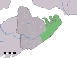
Nieuw-Namen — Town — The town centre (dark green) and the statistical district (light green) of Nieuw-Namen in the municipality of Hulst. Coordinates: 51°17′35″N 4°9′44″E / 51.29306°N 4.16222°ECoordinates: 51°17′35″N 4°9′44″E / 51.29306°N 4.16222°E Country Netherlands Province Zeeland Municipality Hulst Population (1 January 2010) - Total 1,057 Time zone CET (UTC+1) - Summer (DST) CEST (UTC+2) Postal code Nieuw-Namen is a town in the Dutch province of Zeeland. It is a part of the municipality of Hulst, and lies about 24 km south of Bergen op Zoom.
In 2001, the town of Nieuw-Namen had 770 inhabitants. The built-up area of the town was 0.23 km², and contained 354 residences.[1] The statistical area "Nieuw-Namen", which also can include the peripheral parts of the village, as well as the surrounding countryside, has a population of around 1040.[2]
References
- ^ Statistics Netherlands (CBS), Bevolkingskernen in Nederland 2001. (Statistics are for the continuous built-up area).
- ^ Statistics Netherlands (CBS), Statline: Kerncijfers wijken en buurten 2003-2005. As of 1 January 2005.
Cities/towns Villages Clinge - Graauw - Heikant - Hengstdijk - Kapellebrug - Kloosterzande - Kuitaart - Lamswaarde - Nieuw-Namen - Ossenisse - Sint Jansteen - Terhole - Vogelwaarde - WalsoordenHamlets Absdale - Baalhoek - Boschkapelle - Duivenhoek - Drie Hoefijzers - Eendragt - Emmadorp - Groenendijk - Halfeind · Kampen - Kamperhoek - Knuitershoek - Krabbenhoek - Kreverhille - Kruisdorp - Kruispolderhaven - Margret - Luntershoek - Molenhoek - Noordstraat - Oude Stoof - Paal - Patrijzenhoek - Pauluspolder - Prosperdorp - Stoppeldijk/Rapenburg - Roverberg - Ruischendegat - Schapershoek - Scheldevaartshoek - Schuddebeurs - Sluis - Statenboom - Stoppeldijkveer - Tasdijk - Vogelfort - Zandberg - ZeedorpList of cities, towns and villages in Zeeland Categories:- Populated places in Zeeland
- Zeeland geography stubs
Wikimedia Foundation. 2010.


