Dniester Liman

Dniester Liman
Dniester Estuary
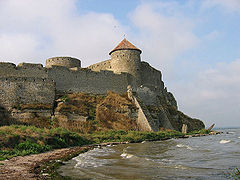
The coast of the estuary near the castle of Bilhorod-Dnistrovskyi
Location Ukraine
Coordinates 46°14′N 30°21′E / 46.233°N 30.35°E / 46.233; 30.35Coordinates: 46°14′N 30°21′E / 46.233°N 30.35°E / 46.233; 30.35
Lake type estuary
Primary inflows Dniester
Basin countries Ukraine
Max. length 45.2 км
Max. width 12 км
Surface area 360-408 km²
Average depth 1.8 m
Max. depth 2.7 m
Settlements Bilhorod-Dnistrovskyi

Dniester Liman of Dniester Estuary (Ukrainian: Дністровський лиман, Romanian: limanul Nistrului) is a liman, formed at the point where the river Dniester flows into the Black Sea. It is located in Ukraine, in Odessa Oblast. The city of Bilhorod-Dnistrovskyi lies on its western shore and Ovidiopol on its eastern shore. Shabo, situated downstream of Bilhorod-Dnistrovskyi, is known for its wine. The estuary hosts the Bilhorod-Dnistrovsky Seaport.

The area of the liman varies between 360 and 408 km², it is 42,5 km long and has maximum width of 12 km. The average depth is 1,8 m, the maximum depth 2,7 m.

External links

See also

  • Berezan Estuary
  • Tyligul Estuary
  • Hryhorivsky Estuary
  • Khadzhibey Estuary
  • Sukhyi Estuary

Wikimedia Foundation. 2010.

Игры ⚽ Поможем сделать НИР

Look at other dictionaries:

  • Limán del Dniéster — Foto del satélite Landsat del limán del Dniéster. El limán del Dniéster (ucraniano, Дністровський лиман; rumano, limanul Nistrului) es un limán, formado en el punto en el que el río Dniéster desemboca en el mar Negro. Se encuentra en Ucrania, en… …   Wikipedia Español

  • Liman (landform) — [ Landsat satellite photo of limans along the Black Sea coast] [ Dniester Liman forming the Dniester river estuary] Liman is a name for a lake or estuary formed at the mouth of a river where flow is blocked by a bar of sediments. Liman can be… …   Wikipedia

  • Dniester — Nistru redirects here. For the village in Maramureş County, Romania, see Tăuţii Măgherăuş. Nistria redirects here. For the village in Neamţ County, Romania, see Boghicea. Dniester, Dnister, Nistru Дністер …   Wikipedia

  • Limán — Kuyálnik, cerca de Odesa, Ucrania …   Wikipedia Español

  • Dniéster — El río Dniéster País que atraviesa  Moldavia …   Wikipedia Español

  • Dniester — Vorlage:Infobox Fluss/DGWK fehltVorlage:Infobox Fluss/KARTE fehlt Dnister (Dnjestr) Schleife des Dnister beim Dorf Piliptsche zwischen Salischtschyky und Me …   Deutsch Wikipedia

  • Dniester — Dniestr Dniestr Le Dniestr près de Ţipova. Caractéristiques Longueur 1 362 km Bassin 72 100&# …   Wikipédia en Français

  • Lista Ramsar de humedales de importancia internacional — Contenido 1 Lista de sitios por país 1.1 Albania 1.2 Alemania 1.3 Argentina …   Wikipedia Español

  • Bilhorod-Dnistrovskyi — (Ukrainian: Білгород Дністровський, transliteration: Bilhorod Dnistrovs’kyi, Romanian: Cetatea Albă) is a city situated on the right bank of the Dniester Liman (on the Dniester estuary leading to the Black Sea) in the Odessa Oblast (province) of… …   Wikipedia

  • Ovidiopol — (Ukrainian: Овідіополь, translit.: Ovidiopol; Russian: Овидиополь, translit.: Ovidiopol ; Turkish: Hacıdere ) is a coastal town in Odessa Oblast, Ukraine. It is located at around 46°14′41″N …   Wikipedia

Share the article and excerpts

Direct link
Do a right-click on the link above
and select “Copy Link”