- Traffic Bridge (Saskatoon)
Infobox Bridge
bridge_name = Traffic Bridge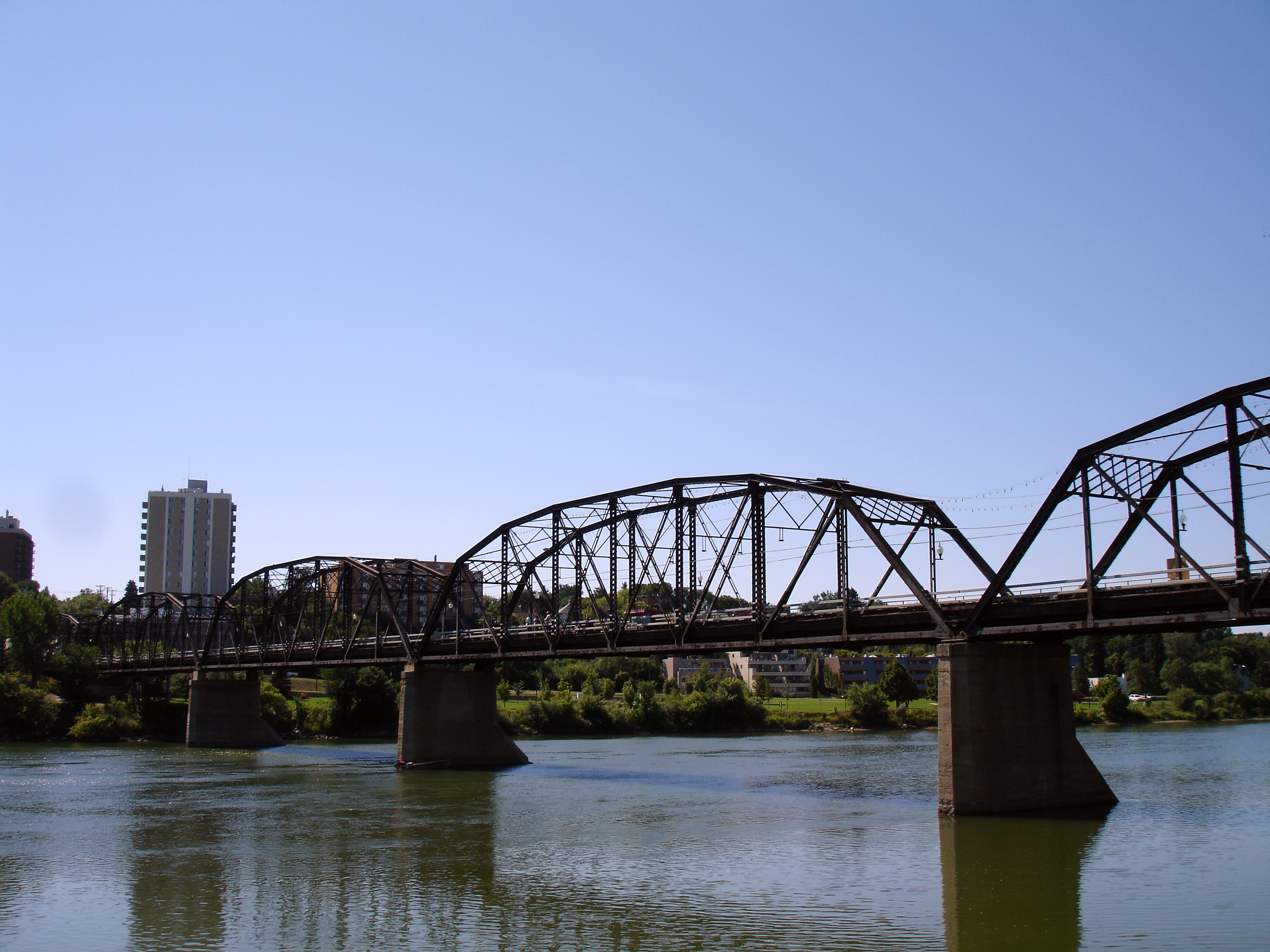
caption = Traffic Bridge over theSouth Saskatchewan River
official_name = Traffic Bridge
carries = 2 lanes of Victoria Avenue/3rd Avenue South
crosses =South Saskatchewan River
locale = Saskatoon, Saskatchewan,Canada
maint = City of Saskatoon
id =
designer =
design = Parker truss bridge
material = Steel, wood, concrete
spans =
pierswater = 4
mainspan =
length = convert|950|ft|m|0
width =
height =
load =
clearance =
below =
traffic =
begin = 1906
complete =
open = 1907-10-10
closed =
toll =
map_cue =
map_
map_text =
map_width =
coordinates =
lat =
long =The Traffic Bridge is a
truss bridge that spansSouth Saskatchewan River , connecting Victoria Avenue to 3rd Avenue South and Spadina Crescent inSaskatoon ,Saskatchewan ,Canada . OpenedOctober 10 ,1907 , it was the first vehicle bridge in Saskatoon, replacing an expensive and erratic ferry service.cite web
last =
first =
authorlink =
coauthors =
title = City History - Riveredge
work =
publisher = City of Saskatoon
date =
url = http://www.saskatoon.ca/org/city_history/river/traffic.asp
format =
doi =
accessdate = 2000-06-14] The promised construction of the bridge was considered a prime factor in the amalgamation of the towns of Saskatoon, Nutana and Riversdale. The Traffic Bridge was the only road bridge in Saskatoon until 1916 when the University Bridge was completed.cite web
last = Herrington
first = Ross
authorlink =
coauthors =
title = Statement of Heritage Significance - Traffic (Victoria or 19th Street) Bridge, Saskatoon
work =
publisher = Ministry of Tourism, Parks, Culture and Sport
date = 2008-03-02
url = http://www.tpcs.gov.sk.ca/TrafficBridge
format =
doi =
accessdate = 2008-09-29]Names
The bridge is known both popularly and in official correspondence as the Traffic Bridge, originally distinguishing it from the QLLS/CN railway bridge just upstream and later becoming a proper noun in its own right (the railway bridge was built in 1890 and demolished in 1965 when the rail line and downtown yards were removed; the
Senator Sid Buckwold Bridge now crosses the river at its former location). Although it is Saskatoon's oldest bridge, it was the last one to be formally named. On January 22, 2007, Saskatoon City Council voted to officially name it the "Traffic Bridge", on the recommendation of the Municipal Heritage Advisory Committee, as a way to acknowledge its historic character and the vital role it played in the city's early history.The bridge has been referred to by various names since its construction. The most popular alternate name is Victoria Bridge, given that Victoria Avenue runs right up to the bridge's east end. It has been called the 19th Street Bridge, although 19th street actually passes a block north of the bridge and connects with the northwest end of Broadway Bridge (this name made more sense prior to the construction of Broadway Bridge, when the
streetcar line came down 19th street before turning onto the bridge). Due to its colour, it has also been called the Black Bridge, although its most recent painting is a rather dark grey. It is also sometimes called the Iron Bridge and even the Short Hill Bridge after the Short Hill, down which Victoria Avenue comes.History
The Traffic Bridge came into being when residents of Nutana agreed to merge with the town of Saskatoon and the village of Riversdale to form a city. As a condition of their joining with the other two communities, they demanded that a bridge be built for foot and vehicular traffic. Up to then, the only way to cross the river was on an unreliable ferry, or a difficult and sometimes dangerous walk across the railway bridge. The province provided funding and John Gunn and Sons was selected as the contractor.cite web
last = Herrington
first = Ross
authorlink =
coauthors =
title = Saskatchewan Road and Railway Bridges to 1950: Inventory
work =
publisher = Ministry of Tourism, Parks, Culture and Sport
date = 2007-03-31
url = http://www.tpcs.gov.sk.ca/BridgeInventory
format =
doi =
accessdate = 2007-09-29] On October 10, 1907, the Traffic Bridge officially opened.cite web
last = Jeff
first = O'Brien
authorlink =
coauthors =
title = A History of Saskatoon to 1914
work =
publisher = City of Saskatoon - Archives
month = July | year = 2005
url = http://www.saskatoon100.ca/docs/SaskatoonHistoryto1914.pdf
format =
doi =
accessdate = 2007-10-18]Less than a year after it opened, on
June 7 ,1908 , the bridge became of the site of Saskatoon's only marine "disaster" when asteamboat called the "S.S. City of Medicine Hat" crashed into one of the bridge's piers and sank; all aboard managed to make it to safety. [http://www.saskatoon.ca/org/city_history/river/medhat.asp City History—Riveredge] The "City of Medicine Hat".] This accident marked the end of steamboat traffic on the river. An anchor presumed to be the "City of Medicine Hat"'s was located in August 2006 by divers training just downstream, near the Broadway Bridge. [http://www.cbc.ca/canada/saskatchewan/story/2006/09/14/anchor.html Anchor believed to have come from historic wreck] ,September 14 ,2006 .]Two roadways cut out of the riverbank are often associated with the Traffic Bridge. Short Hill referred to the steep rise up the east bank from the foot of the bridge along Victoria Avenue. The grade was too steep for most wagon teams, as well as the streetcars that began operation in 1913. [cite web
last =
first =
authorlink =
coauthors =
title = City History - Riveredge - The Short Hill, 1914
work =
publisher = City of Saskatoon
date =
url = http://www.city.saskatoon.sk.ca/org/city_history/river/short.asp
format =
doi =
accessdate = 2007-10-18] Long Hill referred to the more gradual slope up the east riverbank from the foot of the bridge to the end of 12th Street, around where the end of the Broadway Bridge is today. This road followed the old ferry road up the bank along what is now Saskatchewan Crescent. Even the Long Hill was difficult for streetcars; in March 1922, a streetcar derailed when it slid off ice-covered tracks while attempting to turn onto the bridge. [cite web
last =
first =
authorlink =
coauthors =
title = City History - Riveredge - The Long Hill, 1915
work =
publisher = City of Saskatoon
date =
url = http://www.city.saskatoon.sk.ca/org/city_history/river/long.asp
format =
doi =
accessdate = 2007-10-18]The pedestrian walkway on the upstream side of the bridge was added a few years after it opened. In 1961, the southern end of the bridge was raised to reduce the slope on the Short Hill and to improve traffic flow, allowing Saskatchewan Crescent to pass underneath the bridge. The bridge carries approximately 10,000 vehicles per day.
The bridge was repainted in 1979, albeit as little or no surface preparation was done the work was of dubious structural benefit. Beginning in the 1980s, the bridge started to show its age and needed to be closed periodically for refurbishment. Some adjustments were also made to widen the roadway, as many modern motorists were experiencing difficulty crossing the bridge. It was also closed for extended periods of time in the early 1990s when City of Saskatoon work crews damaged the bridge twice by driving over the bridge with vehicles too heavy or too large for the bridge specifications.
On
September 6 ,2005 , the City of Saskatoon closed the bridge for inspection, in preparation for planned upgrades to the roadway (including the installation of the city's firstroundabout (since the removal of the "traffic circle" on 8th Street a decade earlier) just off the north end of the bridge) in anticipation of an adjacent riverfront development (River Landing ). On November 2, the bridge was closed indefinitely to vehicular traffic upon completion of the inspection, due to corrosion and other factors. The bridge was re-opened onSeptember 8 ,2006 , following repairs that cost $500,000. The bridge remained open to pedestrian and bicycle traffic for most of this period. Replacing the bridge instead of repairing it would have cost between $24 and $45 million. [http://www.canada.com/saskatoonstarphoenix/story.html?id=12bf9854-cfba-46a2-8ec1-444e93ef4ed1&k=44925 Victoria Bridge may reopen] ,February 9 ,2006 .]Without major repairs, engineers now give the bridge a 20 year life expectancy (either as a vehicle or a pedestrian crossing). The job of sandblasting the bridge to bare metal and re-painting it is made very expensive by the need to keep all sandblasting debris out of the river as the existing paint is lead-based.
The bridge's arches were equipped with several series of decorative LED lights in the summer of 2007. They included a programmable controller that makes the lights change colour and move in different patterns. However, the lights have proved controversial; they cost the city $462,000, which was almost twice the city's original estimate. They have also broken down frequently since installation, fueling further complaints from the public about their high price tag. [cite web
last = Nickel
first = Rod
authorlink =
coauthors =
title = Two Traffic Bridge arches strung with lights have gone dark
work =
publisher = The StarPhoenix
date = 2008-07-07
url = http://www.canada.com/saskatoonstarphoenix/story.html?id=59f83c8b-d21f-4432-8e3a-a1de68888721
format =
doi =
accessdate = 2008-10-03]References
ee also
*
List of bridges in Canada
*List of bridges
* List of other Victoria Bridges (disambiguation)External links
* [http://www.cbc.ca/canada/saskatchewan/story/2006/09/22/roundabouts.html For Saskatoon drivers, what goes around comes around]
Wikimedia Foundation. 2010.