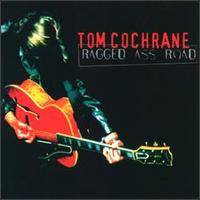
Ragged Ass Road

Ragged Ass Road

Infobox Album | Name = Ragged Ass Road
Type = Album
Artist = Tom Cochrane


Released = October 1995
Recorded = 1995
Genre = Heartland rock
Length = 53:53
Label = Capitol
Producer = Tom Cochrane, John Webster
Reviews =
*Allmusic Rating|3|5 [http://www.allmusic.com/cg/amg.dll?p=amg&sql=Aidjb7ioog72r link]
Last album = "Mad Mad World"
(1991)
This album = "Ragged Ass Road"
(1995)
Next album = "Songs of a Circling Spirit"
(1997)

"Ragged Ass Road" is an album by Canadian rocker Tom Cochrane. The album was released in October 1995 (see 1995 in music), and is named for a real road which exists in Yellowknife, Northwest Territories.

The title track was featured in the "Mask" episode of Due South.

Track listing

# "I Wish You Well" (Cochrane) – 4:24
# "Wildest Dreams" (Cochrane) – 4:12
# "Just Scream" (Cochrane) – 4:53
# "Paper Tigers" (Cochrane) – 3:56
# "Crawl" (Bell/Cochrane) – 4:15
# "Ragged Ass Road" (Cochrane) – 4:45
# "Flowers in the Concrete" (Ducharme) – 4:02
# "Dreamer's Dream" (Cochrane) – 4:57
# "Message (Rise Up Again)" (Cochrane) – 4:33
# "Best Waste of Time" (Ducharme) – 4:36
# "Will of the Gun" (Ducharme) – 4:46
# "Song Before I Leave" (Cochrane) – 4:34

Personnel

* Tom Cochrane - guitars, harmonica, mandolin, vocals
* John Webster - keyboards, engineer
* Ken "Spider" Sinnaeve - bass
* Alex Lifeson - guitar
* Bill Bell - guitars (acoustic & electric)
* Annette Ducharme - guitar (acoustic), backing vocals
* Dick Smith - percussion
* Gregor Beresford - percussion, drums
* Evanne Cochrane - vocals
* Molly Johnson - backing vocals
* Saffron Henderson - backing vocals


Wikimedia Foundation. 2010.

Игры ⚽ Нужно решить контрольную?

Look at other dictionaries:

  • Ragged Ass Road (street) — Ragged Ass Road is a well known street in Yellowknife, Northwest Territories; Tom Cochrane named his album Ragged Ass Road after it. The street itself was named by Lou Rocher and his friends after a season of hard work and no profit; they were… …   Wikipedia

  • Canol Road — Die Straße beim Rose River Die Canol Road (oder auch Canadian Oil Road) war ursprünglich ein Projekt aus dem zweiten Weltkrieg, bei dem es darum ging, eine Pipeline von dem Ort Norman Wells nach Whitehorse zu führen. Heute existiert die Pipeline… …   Deutsch Wikipedia

  • Tibbitt to Contwoyto Winter Road — Die Tibbitt to Contwoyto Winter Road ist eine 568 km lange Eisstraße in den Nordwest Territorien und dem Territorium Nunavut im Norden Kanadas. Sie wird jährlich für einen Zeitraum von ca. 60 Tagen errichtet und führt zu 87% über zugefrorene …   Deutsch Wikipedia

  • Tom Cochrane — Tom Cochrane, Ottawa 2003 Background information Born May 14, 1953 (1953 05 14) (age 58) …   Wikipedia

  • Tom Cochrane — (* 14. Mai 1953 in Lynn Lake, Manitoba, Kanada) ist ein kanadischer Sänger und Komponist. Nach einem wenig erfolgreichen Soloalbum, dass Cochrane 1974 herausgebracht hatte, wurde er 1978 Leadsänger der Gruppe Red Rider. Die Gruppe hatte mehrere… …   Deutsch Wikipedia

  • Tom Cochrane — Pour les articles homonymes, voir Cochrane. Tom Cochrane Naissance 14 mai 1953 (1953 05 14) (58 ans) Lynn Lake,Manitoba,Canada …   Wikipédia en Français

  • Street sign theft — occurs when street signs are stolen, often to be used as decorations, but also sometimes to avoid obeying the law by claiming later the sign was not there.Fact|date=January 2008 Although the theft often seems arbitrary, unusual or amusing signs… …   Wikipedia

  • Yellowknife — Infobox Settlement official name = Yellowknife, Northwest Territories native name = Somba K e nickname = motto = Multum In Parvo (Much In Little) imagesize = image caption = Downtown Yellowknife image mapsize = 200px map caption = subdivision… …   Wikipedia

  • Ingraham Trail — Symbol des Ingraham Trail Der Ingraham Trail ist eine etwa 65 km (43 Meilen) lange Straße in den Nordwest Territorien im Norden Kanadas und verläuft zwischen Yellowknife und dem Tibbitt Lake. In Wintermonaten geht der Ingraham Trail in die… …   Deutsch Wikipedia

  • Dempster Highway — Der Dempster Highway in der Nähe der Grenze zwischen Yukon und NWT. Bild aufgenommen auf dem Wright Pass in Richtung Süden zu den Richardson Mountains …   Deutsch Wikipedia

Share the article and excerpts

Direct link
Do a right-click on the link above
and select “Copy Link”