- Mtera Dam
-
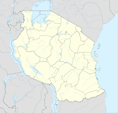
Mtera Dam Map of Tanzania showing the location of Mtera Dam Location Mtera, Tanzania Coordinates 07°08′12″S 35°59′16″E / 7.13667°S 35.98778°ECoordinates: 07°08′12″S 35°59′16″E / 7.13667°S 35.98778°E Construction began 1975 Opening date 1979 Dam and spillways Impounds Great Ruaha River Reservoir Capacity 125000000 m³ Catchment area 68000 km² Surface area 660 km² Power station Owner(s) Tanesco Commission date 1979 Installed capacity 80 MW Mtera Dam is a hydroelectric dam in Tanzania. The dam is located midway between Iringa and Dodoma on the border between the Iringa Region and the Dodoma Region. The travel time from Dodoma is about three hours on a gravel road.
Contents
Overview
Mtera Dam is the biggest hydroelectric dam in Tanzania. It measures 660 square kilometers at full capacity. The lake is 56 km long, and 15 km width, and is feed by the Great Ruaha River and the Kisigo River. It was built from 1975 to 1979 for the purpose of regulating water level at the downstream at the Ruaha installed Kidatu Hydro-electric Dam. Its capacity is 80 MW.
Ecology
The lake is considered one of the best places in Tanzania to observe birds, since in it are at the one million dead trees, and he has many shallow areas.[1] In addition, the waters are rich in fish. In the early 1990s were a year about 5000 tonnes of fish caught in the lake.[2]
References
- ^ http://www.birdlife.org/datazone/sites/index.html?action=SitHTMDetails.asp&sid=6992&m=0
- ^ http://www.fao.org/docrep/005/v4110e/V4110E06.htm
See also
- Tanesco
- List of hydropower stations in Africa
External links
- Tanesco Website
Categories:- Buildings and structures completed in 1979
- Dams in Tanzania
- Hydroelectric power stations in Tanzania
Wikimedia Foundation. 2010.

