Old Fort Pierce Park

Old Fort Pierce Park
Fort Pierce Site
Location: S. Indian River Drive
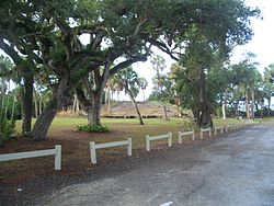
Fort Pierce, Florida 34950
Coordinates: 27°26′11″N 80°19′14″W / 27.43639°N 80.32056°W / 27.43639; -80.32056Coordinates: 27°26′11″N 80°19′14″W / 27.43639°N 80.32056°W / 27.43639; -80.32056
Built: 1838[2]
Governing body: Local
NRHP Reference#: 74002181[1]
Added to NRHP: January 11, 1974[3]

Old Fort Pierce Park is the site of Fort Pierce, a military installation constructed by the U.S. Army in Florida with the purpose of being a main supply depot for the army during the Second Seminole War. The modern town of Fort Pierce derives its name from this installation.

Fort Pierce, named for its first commander Benjamin Pierce, was built in 1838 and abandoned in 1842 at the end of the Second Seminole War, burning down the following year.

Today, the site is a park along the Indian River. The park is also the site of an ancient burial mound of the Ais Indians.

References

  1. ^ St. Lucie County listings at the National Register of Historic Places
  2. ^ "Fort Pierce Site". Florida Heritage Tourism Interactive Catalog. Florida's Office of Cultural and Historical Programs. 2007-04-08. http://www.flheritage.com/services/sites/fht/record_t.cfm?ID=912&type=c&index=56. 
  3. ^ "National Register Information System". National Register of Historic Places. National Park Service. 2007-01-23. http://nrhp.focus.nps.gov/natreg/docs/All_Data.html. 

External links


Wikimedia Foundation. 2010.

Игры ⚽ Нужна курсовая?

Look at other dictionaries:

  • Old Fort Pierce City Hall — U.S. National Register of Historic Places …   Wikipedia

  • Old Fort Pierce Post Office — Fort Pierce Old Post Office U.S. National Register of Historic Places …   Wikipedia

  • Fort Pierce, Florida — Infobox Settlement official name = Fort Pierce, Florida other name = native name = nickname = settlement type = City motto = imagesize = image caption = flag size = image seal size = image shield = shield size = image blank emblem = blank emblem… …   Wikipedia

  • Old St. Anastasia Catholic School — U.S. National Register of Historic Places …   Wikipedia

  • Fort Adams — Infobox Military Structure name=Fort Adams location=Newport, Rhode Island caption= type=Coast Artillery Post built=1799; 1841 materials= used=1799 1824; 1841 1953 controlledby=United States garrison= commanders=Captain John Henry battles=Infobox… …   Wikipedia

  • Fort Ross, California — Infobox nrhp | name =Fort Ross nrhp type =nhl caption = nearest city= Fort Ross, California lat degrees = 38 lat minutes = 30 lat seconds = 51.44 lat direction = N long degrees = 123 long minutes = 14 long seconds = 33.75 long direction = W… …   Wikipedia

  • Old City (Knoxville) — Southern Terminal and Warehouse Historic District U.S. National Register of Historic Places U.S. Historic district …   Wikipedia

  • Fort Ticonderoga — Pour les articles homonymes, voir Ticonderoga. Fort Carillon (1755 1759) Fort Ticonderoga (depuis 1759) Fort Ticonderoga, d …   Wikipédia en Français

  • Terry Park Ballfield — Infobox Stadium stadium name = Terry Park Ballfield nickname = location = 3410 Palm Beach Boulevard Fort Myers, Florida USA coordinates = broke ground = 1921 opened = 1925 renovated = 1955 (Rebuilt) expanded = closed = demolished = 1943 by Fire… …   Wikipedia

  • Crystal River Archaeological State Park — Crystal River Indian Mounds U.S. National Register of Historic Places U.S. National Historic Landmark …   Wikipedia

Share the article and excerpts

Direct link
Do a right-click on the link above
and select “Copy Link”