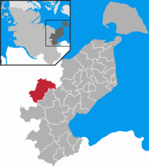
- Malente
-
This Article is about a German location. For the DJ with the same name, see Malente (DJ).
Malente 
Coordinates 54°10′N 10°33′E / 54.16667°N 10.55°ECoordinates: 54°10′N 10°33′E / 54.16667°N 10.55°E Administration Country Germany State Schleswig-Holstein District Ostholstein Local subdivisions 12 Mayor Michael Koch (CDU) Basic statistics Area 69.06 km2 (26.66 sq mi) Elevation 32 m (105 ft) Population 10,810 (31 December 2010)[1] - Density 157 /km2 (405 /sq mi) Other information Time zone CET/CEST (UTC+1/+2) Licence plate OH Postal code 23714 Area code 04523 Website www.malente.de Malente is a municipality in the district of Ostholstein, in Schleswig-Holstein, Germany. It is about 5 km northwest of Eutin and 35 km north of Lübeck.
References
- ^ "Statistikamt Nord: Bevölkerung in Schleswig-Holstein am 31. Dezember 2010 nach Kreisen, Ämtern, amtsfreien Gemeinden und Städten" (in German). Statistisches Amt für Hamburg und Schleswig-Holstein. 31 December 2010. http://www.statistik-nord.de/uploads/tx_standocuments/A_I_2_vj104_S.pdf.
External links
- (German) Official site
Towns and municipalities in Ostholstein Ahrensbök | Altenkrempe | Bad Schwartau | Beschendorf | Bosau | Dahme | Damlos | Eutin | Fehmarn | Göhl | Gremersdorf | Grömitz | Großenbrode | Grube | Harmsdorf | Heiligenhafen | Heringsdorf | Kabelhorst | Kasseedorf | Kellenhusen | Lensahn | Malente | Manhagen | Neukirchen | Neustadt in Holstein | Oldenburg in Holstein | Ratekau | Riepsdorf | Scharbeutz | Schashagen | Schönwalde am Bungsberg | Sierksdorf | Stockelsdorf | Süsel | Timmendorfer Strand | Wangels Categories:
- Municipalities in Schleswig-Holstein
- Ostholstein geography stubs
Wikimedia Foundation. 2010.


