- Chevak Airport
-
Chevak Airport 
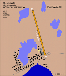
IATA: VAK – ICAO: PAVA – FAA LID: VAK Summary Airport type Public Owner State of Alaska DOT&PF - Central Region Location Chevak, Alaska Elevation AMSL 75 ft / 23 m Coordinates 61°32′27″N 165°36′03″W / 61.54083°N 165.60083°W Runways Direction Length Surface ft m 2/20 3,200 975 Gravel 18W/36W 2,000 610 Water Source: Federal Aviation Administration[1] Chevak Airport (IATA: VAK, ICAO: PAVA, FAA LID: VAK) is a public airport located one mile (1.6 km) north of the central business district of Chevak, a city in the Wade Hampton Census Area of the U.S. state of Alaska. The airport is owned by the state.[1]
Contents
Facilities
Chevak Airport has one runway and one seaplane landing area:[1]
- Runway 14/32: 2,680 x 50 ft. (817 x 15 m), Surface: Gravel
- Runway 18W/36W: 2,000 x 400 ft. (610 x 122 m), Surface: Water
Airlines and destinations
- Aero Flight (Bethel, Hooper Bay)
- Era Alaska (Hooper Bay)
Top Destinations
Busiest domestic routes out of VAK
(July 2010 - June 2011) [2]Rank City Passengers Carriers 1  Bethel, AK
4,000 Grant, Hageland References
External links
- Resources for this airport:
- Airport information for PAVA at AirNav
- Accident history for VAK at Aviation Safety Network
- Aeronautical chart for VAK at SkyVector
Categories:- Airports in the Wade Hampton Census Area, Alaska
- Alaska airport stubs
Wikimedia Foundation. 2010.
