- Haarlemmerliede
Dutch town locator maps
mun_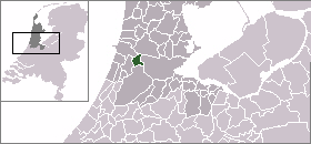
town_
caption = The village (dark red) and the statistical district (light green) of Haarlemmerliede in the municipality of Haarlemmerliede en Spaarnwoude.Haarlemmerliede (coord|52|23|N|4|41|E|type:city(300)) is a small village in the Dutch province of
North Holland . It is a part of the municipality ofHaarlemmerliede en Spaarnwoude , and lies about 4 km east ofHaarlem .Haarlemmerliede was a separate municipality between 1817 and 1857, when it merged with
Spaarnwoude . [Ad van der Meer and Onno Boonstra, "Repertorium van Nederlandse gemeenten", KNAW, 2006. [http://www.knaw.nl/cfdata/publicaties/detail.cfm?boeken__ordernr=20061061] ]The statistical area "Haarlemmerliede", which also can include the surrounding countryside, has a population of around 300.Statistics Netherlands (CBS), [http://statline.cbs.nl/ "Statline: Kerncijfers wijken en buurten 2003-2005"] . As of
January 1 ,2005 .]References

Wikimedia Foundation. 2010.