Jipsinghuizen — 52°58′37″N 7°8′59″E / 52.97694, 7.14972 … Wikipédia en Français
Gronings Ontzet — Folkert Bock: ’’Het beleg van Groningen in 1672’’ (Die Belagerung Groningens 1672) Mit dem lokalen Festtag namens Gronings Ontzet (deutsch: Groninger Entsatz), feiert man in der niederländischen Provinzhauptstadt Groningen alljährlich die… … Deutsch Wikipedia
Plaggenborg — 52°59′9″N 7°9′22″E / 52.98583, 7.15611 … Wikipédia en Français
Hotel de Waalehof — (Jipsinghuizen,Нидерланды) Категория отеля: 2 звездочный отель Адрес: Weenderstraat 4, 9551 … Каталог отелей
Vlagtwedde — Héraldique … Wikipédia en Français
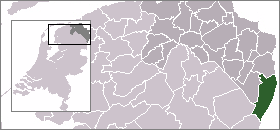
Vlagtwedde — Infobox Settlement official name = Vlagtwedde mapsize = 280px subdivision type = Country subdivision name = Netherlands subdivision type1 = Province subdivision name1 = Groningen area footnotes = (2006) area total km2 = 170.51 area land km2 = 167 … Wikipedia
List of places in the Netherlands — This is an alphabetical list of places (cities, towns, villages) in the Netherlands. Lists per province can be found at:* List of towns in Groningen * List of towns in Friesland * List of towns in Drente * List of towns in Overijssel * List of… … Wikipedia
Vlagtwedde — Gemeinde Vlagtwedde Flagge Wappen Provinz Groningen Bürgermeister … Deutsch Wikipedia
Agodorp — 52°52′N 7°5′E / 52.867, 7.083 Agodorp … Wikipédia en Français
Barnflair — 52°51′5″N 7°4′54″E / 52.85139, 7.08167 … Wikipédia en Français