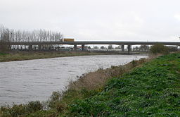
River Clwyd

River Clwyd
River Clwyd (Afon Clwyd)
River
The river Clwyd at Rhuddlan
Country Wales
Region Denbighshire
Source
 - location Clocaenog Forest
Mouth
 - location Liverpool Bay near Rhyl, Wales

The River Clwyd (Welsh: Afon Clwyd) is a river in North Wales which rises in the Clocaenog Forest (grid reference SJ045535) 5 mi (8.0 km) northwest of Corwen.

It flows due south until at Melin-y-Wig it veers northeastwards, tracking the A494 to Ruthin. Here it leaves the relatively narrow valley and enters a broad agricultural vale, the Vale of Clwyd (Welsh: Dyffryn Clwyd). Just south of Denbigh it is joined by the River Clywedog. This substantial tributary also has its source in the Clocaenog Forest but drains out to the east and north of the forest and passes through Cyffylliog, Bontuchel and Rhewl before its confluence with the main river.

Then the Clwyd meanders northwards through the fertile Clwyd valley to St Asaph. Two miles north of St Asaph, the river is joined by a tributary as large as the main river, the River Elwy. In normal flows at low tide, the waters of these two rivers can be seen flowing side by side down the river with little mixing.

The River Elwy has its source a long way to the west on the flanks of Moel Seisiog south-east of Llanrwst. It also has a tributary the River Aled with its source in the upland lake Llyn Aled. The Elwy flows principally eastwards to join the Clwyd passing through few villages. At the confluence of the Elwy and the Clwyd, the river becomes tidal and enters a narrow estuary with lots of wildlife before meeting the Irish Sea at Rhyl.

In 1277 King Edward I sited a castle next to the Clwyd at Rhuddlan. In order for his supply barges to reach the castle, he employed 968 men to work on what was called 'The Great Ditch'. He straightened the 3 mi (4.8 km) stretch of river that ran from the castle to the sea. This was an enormous feat of engineering, compared even to today's modern standards, and it is still possible to make out the original loops and turns of the Clwyd using satellite imagery.

The former county of Clwyd, consisting of the principal areas of modern-day Conwy, Denbighshire, Flintshire and Wrexham, was named after the river, when it was created as a 2-tier county in 1974.

See also

  • Rivers of the United Kingdom

Coordinates: 53°04′13″N 3°25′36″W / 53.07017°N 3.42679°W / 53.07017; -3.42679


Wikimedia Foundation. 2010.

Игры ⚽ Нужно решить контрольную?

Look at other dictionaries:

  • Clwyd — shown within Wales in its original borders Geography Status Non metropolitan county (1974–1996) Preserved county (1996–) 2003 area …   Wikipedia

  • River Elwy — Geobox|River name = River Elwy native name = Afon Elwy other name = category = etymology = nickname = image caption = A view of the river in the 1860s by Francis Bedford (1816–1894) country = Wales country state = region = district = municipality …   Wikipedia

  • Clwyd, River — ▪ river, Wales, United Kingdom       river of northeastern Wales, flowing mainly through Denbighshire but forming the border between Denbighshire and Conwy county borough at its mouth. It rises 7 miles (11 km) southwest of the town of Ruthin and… …   Universalium

  • River Clywedog — This article is about the river near Wrexham. For other rivers of the same name, see Clywedog. Coordinates: 53°1′10.985″N 2°52′56.905″W / 53.01971806°N 2.88247361°W …   Wikipedia

  • Vale of Clwyd — The Vale of Clwyd (Welsh: Dyffryn Clwyd) is a tract of low lying ground in the county of Denbighshire in northeast Wales. The Vale extends south southwestwards from the coast of the Irish Sea for some 20 miles (about 30 km) forming a… …   Wikipedia

  • List of river name etymologies — This page lists the various etymologies (origins) of the names of rivers around the world.Africa*Apies: from Afrikaans meaning little apes *Berg: from Afrikaans meaning mountain *Breede: from Afrikaans meaning wide *Escravos: from Portuguese… …   Wikipedia

  • List of Sites of Special Scientific Interest in Clwyd — This is a list of the Sites of Special Scientific Interest (SSSIs) in the Clwyd Area of Search. For SSSIs elsewhere in Wales, see List of SSSIs by Area of Search.* Afon Dyfrdwy (River Dee) * Alyn Valley Woods and Alyn Gorge Caves * Berwyn * Blaen …   Wikipedia

  • Gwynedd in the High Middle Ages — is a period in the History of Wales spanning the 11th, 12th, and 13th centuries (AD 1000 ndash;1300). The High Middle Ages were preceded by the Early Middle Ages and followed by the Late Middle Ages. Gwynedd is located in the north of… …   Wikipedia

  • List of rivers of Wales — This is a list of rivers of Wales, organised geographically, taken anti clockwise, from Hoylake on Wirral through to the M48 Bridge that separates the estuary of the River Wye from the River Severn. Tributaries are listed down the page in an… …   Wikipedia

  • Ruthin — infobox UK place country= Wales welsh name= Rhuthun constituency welsh assembly= Clwyd West official name= Ruthin latitude= 53.11561 longitude= 3.30578 unitary wales= Denbighshire lieutenancy wales= Clwyd constituency westminster= Clwyd West post …   Wikipedia

Share the article and excerpts

Direct link
Do a right-click on the link above
and select “Copy Link”