Downshire railway station

Downshire railway station
Downshire
Downshire railway station in 2008.jpg
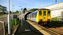
A Class 450 train departs Platform 1 in the Belfast direction, 2008.
Location
Place Downshire
Local authority Carrickfergus
Operations
Platforms in use 2
History
1925
1979
2008
Original station opened
Station renamed Downshire
Station refurbished
NI Railways - Translink - NI railway stations
Portal icon UK Railways portal

Downshire railway station serves eastern Carrickfergus in County Antrim, Northern Ireland.

This station opened on 1 April 1925 and was known for most of its early life as Downshire Park. Northern Ireland Railways renamed the halt in the late 1970s.[1] The station's signposts prior to the 2008 refurbishment named the station as "Downshire Halt", a name by which the station is still locally known.

In June 2011 Translink announced major platform extension works on the Larne Line, including refurbishment of the Belfast-bound platform at Downshire resulting in a two month closure of the platform from 1 July to 31 August 2011.[2] The Larne-bound platform remained open.

Service

From Monday to Saturday there is an hourly service towards Larne Harbour or Belfast Central, with extra services during peak times.

On Sundays there is a two hourly service in each direction.


Preceding station NI Railways Northern Ireland Railways Following station
Carrickfergus   Northern Ireland Railways
Belfast-Larne
  Whitehead

References

  1. ^ "Downshire Park". Railscot - Irish Railways. http://www.railscot.co.uk/Ireland/Irish_railways.pdf. Retrieved 2008-05-08. 
  2. ^ http://translink.co.uk/Timetables/NI-Railways-Timetables/NI-Railways-Engineering-Works-Information/#downshire

Coordinates: 54°43′16″N 5°47′25″W / 54.72111°N 5.79028°W / 54.72111; -5.79028


Wikimedia Foundation. 2010.

Игры ⚽ Поможем написать реферат

Look at other dictionaries:

  • Carrickfergus railway station — Infobox NI station name = Carrickfergus locale = Victoria Street, Carrickfergus borough = Carrickfergus Borough Council years = 1862 2001 events = Original station opened Station refurbished platforms = 3 usage0405 = Carrickfergus railway station …   Wikipedia

  • Downshire — may refer to the following in Northern Ireland: County Down Marquess of Downshire Downshire railway station, Carrickfergus, County Antrim Downshire School, Carrickfergus, County Antrim Downshire Young Men F.C., Hillsborough, County Down Downshire …   Wikipedia

  • List of railway stations in Ireland — This article lists railway stations both in the Republic of Ireland and Northern Ireland. In The Republic of Ireland A * Adamstown * Arklow * Ashtown * Athenry * Athlone * Athy * Attymon B *Bagenalstown *Balbriggan *Ballina *Ballinasloe… …   Wikipedia

  • Belfast-Larne railway line — The Belfast Larne railway line is a picturesque line for the most part. It runs as double track along the majority of its route up the east Antrim coastline from Belfast to Larne serving commuters and ferry passengers. Recently refurbished… …   Wikipedia

  • Multiple units of Ireland — A wide variety of diesel and electric multiple units have been used on Ireland s railways. This page lists all those that have been used. Except with the NIR 3000 class the numbers given by each class in the lists below are those allocated to the …   Wikipedia

  • Hampstead — For other places with the same name, see Hampstead (disambiguation). Coordinates: 51°33′15″N 0°10′28″W / 51.5541°N 0.1744°W / 51.5541; …   Wikipedia

  • Downpatrick — Coordinates: 54°19′19″N 5°42′11″W / 54.322°N 5.703°W / 54.322; 5.703 …   Wikipedia

  • Bracknell — infobox UK place country = England official name= Bracknell shire district= Bracknell Forest shire county = Berkshire region= South East England static static image caption=Charles Square, Bracknell population= 50,131 (2001) [… …   Wikipedia

  • Moira, County Down — Coordinates: 54°28′48″N 6°13′55″W / 54.480°N 6.232°W / 54.480; 6.232 …   Wikipedia

  • Carrickfergus — Infobox UK place official name= Carrickfergus irish name= Carraig Fhearghais map type= Northern Ireland latitude= 54.716 longitude= 5.803 population= 27,201 (2001 Census) irish grid reference= unitary northern ireland= Carrickfergus Borough… …   Wikipedia

Share the article and excerpts

Direct link
Do a right-click on the link above
and select “Copy Link”