Dock Tarn

Dock Tarn
Dock Tarn
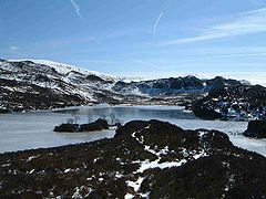
The frozen tarn with the small island in view
Location Lake District, Cumbria
Coordinates 54°31′08″N 3°07′29″W / 54.51876°N 3.12460°W / 54.51876; -3.12460Coordinates: 54°31′08″N 3°07′29″W / 54.51876°N 3.12460°W / 54.51876; -3.12460
Basin countries United Kingdom
Surface elevation 400 m

Dock Tarn is a small tarn located within the Lake District National Park in Cumbria, England at grid reference NY273143. It is situated on moorland at 400 metres above sea level near the summit of Great Crag, midway between Watendlath, the Stonethwaite valley and Borrowdale. It measures approximately 300 by 200 metres, and the shoreline is indented with rocky headlands and bays. There is a tiny island in the tarn with a few small Rowan trees growing on it. Many Lake District writers rate Dock Tarn and the walk to it very highly because of its quiet beauty.

The tarn can be reached from Watendlath by a 2.5 kilometre walk along a path that climbs very close to the summit of Great Crag; many walkers include the ascent of this fell in the outing. The approach from Stonethwaite is of a similar distance but is more arduous, going steeply through the deciduous woodland in the valley before following the stream of Willygrass Gill, which is the outflow of Dock Tarn.


Wikimedia Foundation. 2010.

Игры ⚽ Поможем решить контрольную работу

Look at other dictionaries:

  • Great Crag — Infobox Mountain Name = Great Crag Photo = Great Crag.jpg Caption = Great Crag seen from the Rosthwaite to Watendlath bridleway Elevation = 440 m (1,444 ft) Location = Cumbria, ENG Range = Lake District, Central Fells Prominence = 27 m Parent… …   Wikipedia

  • List of lakes in the Lake District — This list contains the lakes, tarns and reservoirs in the Lake District National Park in Cumbria, England.Note that only one body of water, Bassenthwaite Lake, is officially named a lake . The name mere or water is usually given to a larger body… …   Wikipedia

  • Bassenthwaite Lake — Infobox lake lake name = Bassenthwaite Lake image lake = Bassenthwaite Lake.jpg caption lake = View from Blackstock Point image bathymetry = Bassenthwaite Lakecrop.jpg caption bathymetry = Map (1925) location = Lake District coords =… …   Wikipedia

  • Workington — For other uses, see Workington (disambiguation). Coordinates: 54°38′11″N 3°33′18″W / 54.6365°N 3.5549°W / 54.6365; 3.5549 …   Wikipedia

  • Cumbria — Not to be confused with Cumbia, Umbria, or Cambria. Cumbria …   Wikipedia

  • Marseille — Pour les articles homonymes, voir Marseille (homonymie). 43° 17′ 47″ N 5° 22′ 12″ E …   Wikipédia en Français

  • Aude — For other uses, see Aude (disambiguation). Aude   Department   …   Wikipedia

  • HMS Cornwall (56) — was a County class heavy cruiser of the Kent subclass of the Royal Navy. She was built at Devonport Dockyard (Plymouth, UK), with the keel being laid down on 9 October 1924. She was launched on 11 March 1926, and commissioned 8 May… …   Wikipedia

  • Leeds — This article is about the city of Leeds in England. For the administrative district, see City of Leeds. For other uses, see Leeds (disambiguation). Leeds   City and Metropolitan Borough   City of Leeds …   Wikipedia

  • River Lune — Lune River Lune am Crook o LuneVorlage:Infobox Fluss/KARTE fehlt Daten …   Deutsch Wikipedia

Share the article and excerpts

Direct link
Do a right-click on the link above
and select “Copy Link”