- Bad Münder
-
Bad Münder 
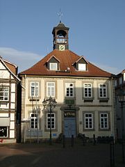
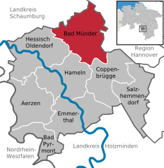
Coordinates 52°11′57″N 9°27′55″E / 52.19917°N 9.46528°ECoordinates: 52°11′57″N 9°27′55″E / 52.19917°N 9.46528°E Administration Country Germany State Lower Saxony District Hameln-Pyrmont Mayor Silvia Nieber (SPD) Basic statistics Area 107.69 km2 (41.58 sq mi) Elevation 119 m (390 ft) Population 17,530 (31 December 2010)[1] - Density 163 /km2 (422 /sq mi) Other information Time zone CET/CEST (UTC+1/+2) Licence plate HM Postal code 31848 Area code 05042 Website www.bad-muender.de Bad Münder (also: Bad Münder am Deister) is a town in the Hamelin-Pyrmont district, in Lower Saxony, Germany, situated on the south side the Deister hills, approximatively 15 km northeast of Hamelin.
References
- ^ "Bevölkerungsfortschreibung" (in German). Landesbetrieb für Statistik und Kommunikationstechnologie Niedersachsen. 31 December 2009. http://www1.nls.niedersachsen.de/statistik/html/parametereingabe.asp?DT=K1000014&CM=Bev%F6lkerungsfortschreibung.
Aerzen | Bad Münder | Bad Pyrmont | Coppenbrügge | Emmerthal | Hamelin | Hessisch Oldendorf | SalzhemmendorfCategories:- Towns in Lower Saxony
- Hanover region geography stubs
Wikimedia Foundation. 2010.


