- Weizhou Island
Infobox Islands
name = Weizhou Island
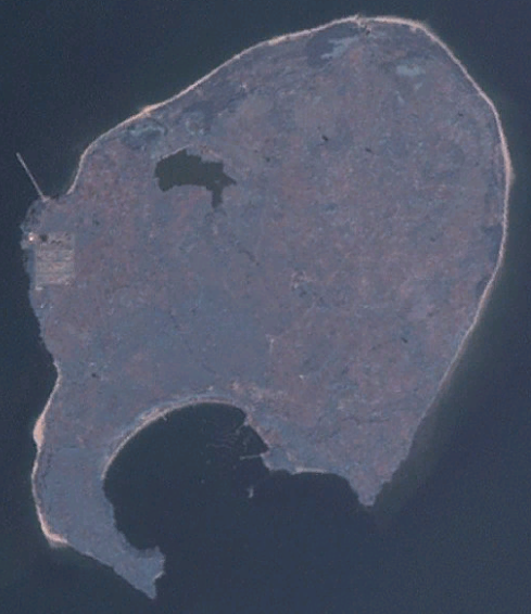
image caption =
image size = 250px
locator
map_custom = no
native name =
native name link =
nickname =
location =
coordinates =
archipelago =
area = 24.74 Square kilometre
length = 6.5 kilometers
width = 6 kilometers
coastline = 15.6 kilometers
highest mount =
elevation =
country = China
country admin divisions title = Province
country admin divisions =Guangxi
country admin divisions title 1 = City
country admin divisions 1 =Beihai
country admin divisions title 2 =
country admin divisions 2 =
country capital city =
country largest city =
country largest city population =
country leader title =
country leader name =
population =
population as of =
density =
ethnic groups =
additional info =Weizhou Island (Chinese: 涠洲岛;
pinyin : Wéizhōu Dǎo) is a Chineseisland in theGulf of Tonkin . The largest island ofGuangxi province, Weizhou is west ofLeizhou Peninsula , south ofBeihai , and east ofVietnam .* Area: 24.74 km²
* Temperature: 23 °C
* Precipitation: 1863 mmIts north-south length is 6.5 km, east-west 6 km. The coast is 15.6 km, with 6 to 10 km of sandy beach. Weizhou is higher in the south, where there is Nanwan Port (南灣港; pinyin: nánwān gǎng).From
1869 to1879 , the French built a Gothic-style 15 metreCatholic church in Shengtang Village (盛塘村; pinyin: shèngtáng cūn), Weizhou. Weizhou Chengzai Church (城仔教堂) was built in1880 , also by French Catholics.----
Weizhou (pinyin: Wéizhōu) is a town of
Haicheng District, Beihai City, Guangxi. It includes Weizhou Island (see above) and a smaller 1.89 km²Xieyang (斜阳) Island. It includes 2 neighborhood committees, 9 village committees.
* Area: 26.63 km²
* Population: 15,900External links
* [http://www.beihai.gov.cn/hczfw/xiaguanxiangzhen/weizhouzhen.htm Official site] (in
Simplified Chinese )
* [http://www.weizhou.net/ local site] (inSimplified Chinese and english )
Wikimedia Foundation. 2010.