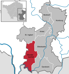
- Mandelbachtal
-
Mandelbachtal 
Coordinates 49°10′N 7°10′E / 49.16667°N 7.16667°ECoordinates: 49°10′N 7°10′E / 49.16667°N 7.16667°E Administration Country Germany State Saarland District Saarpfalz Mayor Herbert Keßler (CDU) Basic statistics Area 57.71 km2 (22.28 sq mi) Elevation 450 m (1476 ft) Population 11,394 (31 December 2010)[1] - Density 197 /km2 (511 /sq mi) Other information Time zone CET/CEST (UTC+1/+2) Licence plate HOM Postal code 66399 Area codes 06803 06804 06893 Website www.mandelbachtal.de Mandelbachtal is a municipality in the Saarpfalz district, in Saarland, Germany. It is situated near the border with France, approx. 15 km southeast of Saarbrücken. Its capital is Ommersheim.

References
- ^ "Fläche, Bevölkerung in den Gemeinden am 31.12.2010 nach Geschlecht, Einwohner je km² und Anteil an der Gesamtbevölkerung" (in German). Statistisches Amt des Saarlandes. 31 December 2010. http://www.saarland.de/dokumente/thema_statistik/staa_FB311209.pdf.
Categories:- Municipalities in Saarland
- Saarland geography stubs
Wikimedia Foundation. 2010.


