- Overmeer
-
Overmeer — Hamlet —  Overmeer in the municipality of Wijdemeren.
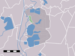
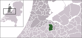
Coordinates: 52°15′15″N 5°05′02″E / 52.25417°N 5.08389°ECoordinates: 52°15′15″N 5°05′02″E / 52.25417°N 5.08389°E Country Netherlands Province North Holland Municipality Wijdemeren Population (1 January 2005) – Total 1,310 Time zone CET (UTC+1) – Summer (DST) CEST (UTC+2) Postal code Overmeer is a village in the Dutch province of North Holland. It is a part of the municipality of Wijdemeren, and lies about 8 km northwest of Hilversum. Overmeer used to be a separate village, but has now grown together with the town of Nederhorst den Berg.
Overmeer has a population of around 1310.[1]
References
- ^ Statistics Netherlands (CBS), Statline: Kerncijfers wijken en buurten 2003-2005 [1]. As of 1 January 2005.
Categories:- Populated places in North Holland
- North Holland geography stubs

Wikimedia Foundation. 2010.