- Whitecraigs railway station
Infobox UK station
name = Whitecraigs
other_name =
code = WCR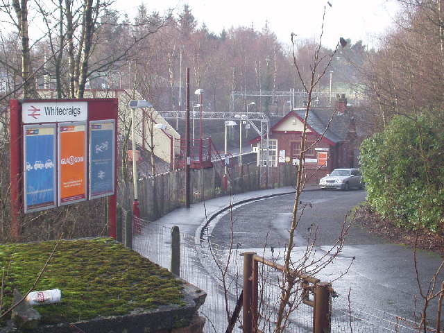
caption =
manager =First ScotRail
locale =Whitecraigs
borough =East Renfrewshire
latitude = 55.790265
longitude = -4.310710
platforms = 2
pte = SPT
usage0203 = 0.225
usage0405 = 0.254
usage0506 = 0.278
original =Lanarkshire and Ayrshire Railway
pregroup =Caledonian Railway
postgroup = LMS
years =1 May 1903 Butt (1995), page 248]
events = OpenedWhitecraigs railway station is a railway station serving the
Whitecraigs area ofEast Renfrewshire ,Scotland . The station is managed byFirst ScotRail and lies on the Neilston branch off the Cathcart Circle.History
The station was originally opened as part of the
Lanarkshire and Ayrshire Railway on1 May 1903 . In some timetables the station was known as Whitecraigs for Rouken Glen.Services
Since electrification in 1962
Since the line was electrified in 1962 the basic service has been a half hour service throughout the day (Mondays to Saturdays), with additional peak hour trains (Mondays to Fridays). From 2005 a half hourly Sunday service has also been provided.
Class 303 "Blue Train" electric multiple units provided almost all trains services for many years thereafter, being joined by the almost similar Class 311 from 1967. Services are now mainly operated by the Class 314 EMUs.
rail line
next = Williamwood
previous = Patterton
route =First ScotRail Cathcart Circle Lines
col = FF80C0rail line
next = Muirend
"Line and station open"
previous = Patterton
"Line and station open"
route =Caledonian Railway Lanarkshire and Ayrshire Railway
col = Caledonian colour
###@@@KEYEND@@@###References
Notes
ources
*
*
*
Wikimedia Foundation. 2010.