Mutford

Mutford

Coordinates: 52°26′N 1°38′E / 52.43°N 1.64°E / 52.43; 1.64

Mutford
Mutford-g3.jpg
Mutford St Andrew
Mutford is located in Suffolk
Mutford

 Mutford shown within Suffolk
District Waveney
Shire county Suffolk
Region East
Country England
Sovereign state United Kingdom
EU Parliament East of England
List of places: UK • England • Suffolk

Mutford is a small village and civil parish located south-west of Lowestoft in the English county of Suffolk. The village is located between Lowestoft and Beccles in a rural area south of the A146 at Barnby. Nearby villages include Gisleham and Henstead. The village gave it's name to the Half Hundred of Mutford which is named in the Domesday Book.

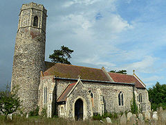
The village consists of a crossroads, at which there is a village store with a Post Office and a few residential streets. The Village hall has a large area of land situated at the back with football matches played regularly. The church of Mutford St Andrew is one of 38 existing round-tower churches in Suffolk and is a Grade I Listed Building.

Sir Stanley Rous, former president of FIFA, was born in Mutford in 1895.[1]

Also born in the village was Bill Crooks, manager of Eastwoodhill Arboretum, Ngatapa, Gisborne, New Zealand from 1967-1974.


References

  1. ^ Pawson.A (2004) ‘Rous, Sir Stanley Ford (1895–1986)’, rev. Oxford Dictionary of National Biography, Oxford University Press (online). Retrieved 2011-04-20.

External links


Wikimedia Foundation. 2010.

Игры ⚽ Нужен реферат?

Look at other dictionaries:

  • Mutford and Lothingland (hundred) — Mutford and Lothingland was a hundred of Suffolk, with an area of 33,368 acres (135.04 km2).[1] Lowestoft Ness, the most easterly point of Great Britain fell within its bounds. Мutford and Lothingland Hundred formed the north eastern corner… …   Wikipedia

  • The Broads — Not to be confused with The Broads, Newfoundland and Labrador. A typical view of the Norfolk Broads The Broads are a network of mostly navigable rivers and lakes in the English counties of Norfolk and Suffolk. The Broads, and some surrounding… …   Wikipedia

  • Oulton Broad North railway station — Oulton Broad North Oulton Broad North station …   Wikipedia

  • Lake Lothing — is a saltwater lake that separates South Lowestoft from North Lowestoft within the county of Suffolk in the United Kingdom. This stretch of water is connected to the North Sea through Lowestoft Harbour and connects to Oulton Broad, part of the… …   Wikipedia

  • East Suffolk — infobox historic subdivision Name= East Suffolk HQ= Ipswich Status= Administrative county Start= 1889 End= 1974 Replace= Suffolk, with a small part transferred to Norfolk Civic= AreaFirst= convert|549241|acre|km2 AreaFirstYear= 1911 AreaLast=… …   Wikipedia

  • Canada Reads — Other names Le Combat des livres Running time 30 min. Country …   Wikipedia

  • History of Suffolk — This article describes the history of Suffolk, the English county.Historical settingAnglo Saxon controlThe county of Suffolk ( Sudfole , Suthfolc , meaning southern folk ) was formed from the south part of the kingdom of East Anglia which had… …   Wikipedia

  • Oulton Broad South railway station — Oulton Broad South Oulton Broad South station, from the platform Loca …   Wikipedia

  • List of places in Suffolk — This is a list of cities, towns and villages in the ceremonial county of Suffolk, England. See the list of places in England for places in other counties.compactTOC NOTOC A* Acton, Aldeburgh, Aldham,Aldringham, Alpheton, Ampton, Ashby,… …   Wikipedia

  • Stanley Rous — Sir Stanley Ford Rous [ [http://www.oxforddnb.com/index/101040150/ Full name] : Oxford Biography Index entry.] (born April 25, 1895 in Mutford, Suffolk; died July 18, 1986 [http://www.aafla.org/OlympicInformationCenter/OlympicReview/1986/ore226/or… …   Wikipedia

Share the article and excerpts

Direct link
Do a right-click on the link above
and select “Copy Link”