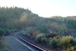
Duncraig railway station

Duncraig railway station
Duncraig National Rail
Duncraig
Location
Place Duncraig
Local authority Highland
Coordinates 57°20′13″N 5°38′13″W / 57.337°N 5.637°W / 57.337; -5.637Coordinates: 57°20′13″N 5°38′13″W / 57.337°N 5.637°W / 57.337; -5.637
Operations
Station code DCG
Managed by First ScotRail
Number of platforms 1
Live arrivals/departures and station information
from National Rail Enquiries
Annual rail passenger usage
2004/05 *   463
2005/06 * decrease 391
2006/07 * decrease 342
2007/08 * increase 485
2008/09 * decrease 388
2009/10 * increase 394
History
?[1] Opened as Duncraig Platform
?[1] Closed
23 May 1949[1] Reopened
10 September 1962[1] Renamed
7 December 1964[1] Closed
5 January 1976[1] Reopened
National Rail - UK railway stations
A B C D E F G H I J K L M N O P Q R S T U V W X Y Z
* Annual passenger usage based on sales of tickets in stated financial year(s) which end or originate at Duncraig from Office of Rail Regulation statistics. Please note: methodology may vary year on year.
Portal icon UK Railways portal

Duncraig railway station is a remote railway station on the Kyle of Lochalsh Line, serving the village of Duncraig in the Highlands, northern Scotland. It features a unique little octagonal waiting room. The station is currently unstaffed.

External links

Preceding station National Rail National Rail Following station
Stromeferry   First ScotRail
Kyle of Lochalsh Line
  Plockton

References

  1. ^ a b c d e f Butt 1995, p. 85.

Sources

  • Butt, R. V. J. (1995). The Directory of Railway Stations: details every public and private passenger station, halt, platform and stopping place, past and present (1st ed.). Sparkford: Patrick Stephens Ltd. ISBN 1-8526-0508-1. OCLC 60251199. 

Wikimedia Foundation. 2010.

Игры ⚽ Поможем сделать НИР

Look at other dictionaries:

  • Warwick railway station, Perth — Warwick Train Station is a Transperth train station 13km from Perth Train Station, in Western Australia. It is on the Joondalup Line .HistoryPrior to the commissioning of the site as a railway station, the location was originally a Bus… …   Wikipedia

  • Joondalup railway line — Legend …   Wikipedia

  • Northern Suburbs Transit System — The Northern Suburbs Transit System is the name given to the project initiated and funded by the Government of Western Australia to provide high speed passenger rail services to the northern corridor of metropolitan Perth, the capital city of… …   Wikipedia

  • Hamersley, Western Australia — Infobox Australian Place | type = suburb name = Hamersley city = Perth state = wa caption = View east from Benjafield Way towards ABC tower lga = City of Stirling area = 3.267 postcode= 6022 pop = 4,965 (2006 census) dist1 = 14 | dir1 = NNW |… …   Wikipedia

  • Beach Road, Perth — Infobox Australian Road road name = Beach Road type = road route route route photo = caption = length = 14 direction = West East start = Marmion finish = Malaga est = 1900 through = Duncraig, Carine, Warwick, Hamersley, Balga, Mirrabooka, Malaga… …   Wikipedia

  • Greenwood, Western Australia — Infobox Australian Place | type = suburb name = Greenwood city = Perth state = wa caption = lga = City of Joondalup postcode = 6024 est = 1970 pop = 9,541 (2006 census)Census 2006 AUS|id=SSC51556|name=Greenwood (State… …   Wikipedia

  • Hepburn Avenue, Perth — Infobox Australian Road road name = Hepburn Avenue route route route photo = caption = length = 14 direction = West East start = Whitfords Avenue, Hillarys finish = Alexander Drive, Alexander Heights est = through = Sorrento, Padbury, Duncraig,… …   Wikipedia

  • Sorrento, Western Australia — Infobox Australian Place | type = suburb name = Sorrento city = Perth state = wa caption = lga = City of Joondalup area = 3.5 postcode = 6020 pop = 7346 (2006 census)Census 2006 AUS|id=SSC52301|name=Sorrento (State… …   Wikipedia

  • Currambine, Western Australia — Currambine Perth, Western Australia Doncaster Park …   Wikipedia

  • Plockton — Infobox UK place official name= Plockton gaelic name= Am Ploc country= Scotland map type= Scotland population= 378 population density= os grid reference= NG803334 edinburgh distance= london distance= latitude= 57.33801 longitude= 5.65231 post… …   Wikipedia

Share the article and excerpts

Direct link
Do a right-click on the link above
and select “Copy Link”