- Indiana State Road 165
Infobox road
state=IN
type=IN
route=165
alternate_name=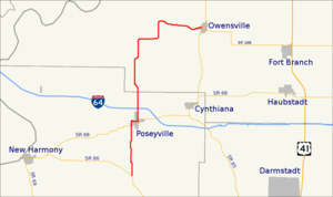
length_mi=17.2
length_round=1
length_ref= [http://illi-indi.com/EndsPage.php?id=1165§ion=1 Indiana Highway Ends - SR 165] ]
established=
direction_a=South
starting_terminus=
junction=
direction_b=North
ending_terminus=
counties=Gibson, Posey
previous_type=IN
previous_route=164
next_type=IN
next_route=166State Road 165 in the
U.S. State ofIndiana starts at State Road 66 near Wadesville, then goes north through Poseyville where it intersects intersectsInterstate 64 at Exit 12. It is also concurrent with State Road 68 for about a mile in Poseyville. It then continues north before going east toward its parent route, State Road 65, at Owensville.Major intersections
Source: INDOT Roadway Referencing System [ [http://www.in.gov/indot/3361.htm INDOT Roadway Referencing System] ] INint
county=Posey
cspan=4
mile=0.00
road=
location=Posey County
notes=SR 165 beginsINint
mile=3.88
road=
type=concur
notes=concurrency begins
location=Poseyville
lspan=3INint
mile=4.83
road=
type=concur
notes=concurrency ends after 0.95 milesINint
mile=5.69
road=
notes=overpassINint
mile=17.19
county=Gibson
road=
location=Owensville
notes=SR 165 endsReferences

Wikimedia Foundation. 2010.