- Stellendam
Dutch town locator maps
mun_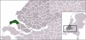
town_
caption = The town centre (darkgreen) and the statistical district (lightgreen) of Stellendam in the municipality of Goedereede.Stellendam (coord|51|48|N|4|2|E|type:city(3246)) is a town in the Dutch province of
South Holland . It is a part of the municipality ofGoedereede , and lies about 9 km west ofHellevoetsluis .In 2001, the town of Stellendam had 3246 inhabitants. The built-up area of the town was 0.6 km², and contained 1311 residences.Statistics Netherlands (CBS), "Bevolkingskernen in Nederland 2001" [http://www.cbs.nl/nl-NL/menu/themas/milieu-natuur-ruimte/ruimte/publicaties/cartografie-geografie/geografische-data/2001-bevolkingskernen-in-nederland.htm] . Statistics are for the continuous built-up area.] The wider statistical district of Stellendam has a population of around 3510.Statistics Netherlands (CBS), "Gemeente Op Maat 2004: Goedereede" [http://www.cbs.nl/nl-NL/menu/themas/nederland-regionaal/nederland-regionaal/publicaties/gemeente-op-maat/2004/alfabet/g/2004-goedereede.htm] .]
Stellendam was a separate municipality between 1817 and 1966, when it became part of Goedereede. [Ad van der Meer and Onno Boonstra, "Repertorium van Nederlandse gemeenten", KNAW, 2006. [http://www.knaw.nl/cfdata/publicaties/detail.cfm?boeken__ordernr=20061061] ]
References
External links
* [http://www.kuijsten.de/atlas/zh/stellendam.html Map of the former municipality in 1868]

Wikimedia Foundation. 2010.