- Koźle
-
For other places with the same name, see Koźle (disambiguation).
Koźle Kosel in 1st half of 18th century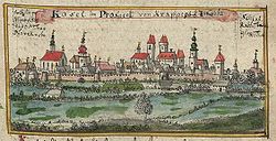
Coordinates: 50°20′7″N 18°8′45″E / 50.33528°N 18.14583°ECoordinates: 50°20′7″N 18°8′45″E / 50.33528°N 18.14583°E Country  Poland
Voivodeship Opole County Kędzierzyn-Koźle Urban Gmina Kędzierzyn-Koźle Time zone CET (UTC+1) – Summer (DST) CEST (UTC+2) Postal code Koźle is a district of Kędzierzyn-Koźle and is at the junction of the Kłodnica and Odra rivers, 29 Ifl. southeast of Opole by rail. The district has a Roman Catholic church, a medieval chateau, remains of a 19th century fortress and a high school. Koźle industries include a shipyard and an inland port.
- History
- First mentioned in the 12th century Gesta principum Polonorum, from 1281 to 1355 Koźle was the seat of an independent Piast duchy. In 1532 it fell to the emperor, it was besieged several times during the Thirty Years War, and it became a Prussian possession by the 1742 Treaty of Breslau. Frederick William II of Prussia converted it into a fortress[citation needed] which held against Austrian sieges in 1758, 1759, 1760 and 1762. In 1807 it almost withstood[specify] a siege by the Von Deroy brigade of the Bavarian Army. The Poles[specify] captured the Odra east bank part of the town during the 1921 Third Silesian Uprising. As a location in one of the Polish areas annexed by Nazi Germany, the "Cosel district" had a subcamp of Auschwitz III (Monowitz) which operated from April 1, 1944 to January 26, 1945.[1] As a part of one of the Recovered Territories a fter World War II,[clarification needed] in 1975 Kędzierzyn, Kłodnica (German: Koldnitz), Koźle, and Sławięcice combined to form Kędzierzyn-Koźle.
References
 Media related to Kędzierzyn-Koźle at Wikimedia Commons
- ^ (German) "6.DV-BEG - Einzelnorm". Bundesministeriaum der Justiz. http://bundesrecht.juris.de/begdv_6/anlage_6.html. Retrieved 2009-12-03.
Categories:- Kędzierzyn-Koźle County
- Opole geography stubs

Wikimedia Foundation. 2010.