- Möhnesee
-
Möhnesee Möhne Reservoir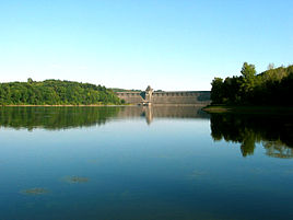


 MöhneseeLocation of Möhnesee within Soest district
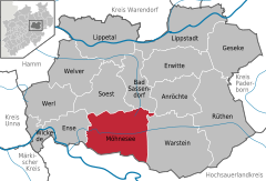

Coordinates 51°29′45″N 8°07′50″E / 51.49583°N 8.13056°ECoordinates: 51°29′45″N 8°07′50″E / 51.49583°N 8.13056°E Administration Country Germany State North Rhine-Westphalia Admin. region Arnsberg District Soest Municipal subdivisions 18 Mayor Hans Dicke (Independent_(politician)) Basic statistics Area 123.38 km2 (47.64 sq mi) Elevation 226 m (742 ft) Population 11,393 (31 December 2010)[1] - Density 92 /km2 (239 /sq mi) Other information Time zone CET/CEST (UTC+1/+2) Licence plate SO Postal code 59519 Area codes 02924,
02925 (Brüllingsen, Ellingsen, Völlinghausen)Website www.moehnesee.de Möhnesee is a municipality in the district of Soest, in North Rhine-Westphalia, Germany.
Contents
Geography
The Möhnesee municipality is situated around the Möhne Reservoir (hence the name), approx. 10 km south of Soest.
History
In the 80s the Möhnesee hosted the Campingkirche.
Neighboring municipalities
On the night of the 16th./17th.May 1943 the Dam which contains the Mohnesee was breached in the attack by Avro Lancaster Bombers of 617 Squadron of the British Royal Air Force.
Notable places
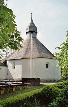 The chapel of Möhnesee-Drüggelte
The Drueggelter Kapelle can be found at Möhnesee-Drüggelte. It is consecrated to the Holy Cross.
Subdivisions
The municipality Möhnesee contains the following 18 subdivisions, with Körbecke as the largest:
- Berlingsen
- Buecke
- Brüllingsen
- Brüningsen
- Delecke
- Echtrop
- Ellingsen
- Günne
- Hewingsen
- Körbecke
- Neuhaus
- Stockum
- Südufer
- Theiningsen
- Völlinghausen
- Wamel
- Westrich
- Wippringsen
References
- ^ "Amtliche Bevölkerungszahlen" (in German). Landesbetrieb Information und Technik NRW. 31 December 2010. http://www.it.nrw.de/statistik/a/daten/amtlichebevoelkerungszahlen/index.html.
External links
- Official site (German)
 Categories:
- Municipalities in North Rhine-Westphalia
- North Rhine-Westphalia geography stubs
- Lakes of North Rhine-Westphalia


Wikimedia Foundation. 2010.