- Nankoku, Kōchi
-
Nankoku
南国市— City — 
FlagLocation of Nankoku in Kōchi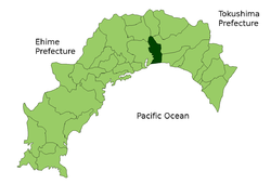

 Nankoku
Coordinates: 33°35′N 133°38′E / 33.583°N 133.633°ECoordinates: 33°35′N 133°38′E / 33.583°N 133.633°E Country Japan Region Shikoku Prefecture Kōchi Government – Mayor Toshihito Hashizume Area – Total 125.35 km2 (48.4 sq mi) Population (March 2008) – Total 50,138 – Density 400/km2 (1,036/sq mi) Time zone Japan Standard Time (UTC+9) City symbols - Tree Yamamomo - Flower Tachibana (Citrus tachibana) - Bird Onagadori (Long tail chicken) Phone number 088-863-2111 Address 2301, Ōsone Kō, Nankoku-shi, Kōchi-ken
783-8501Website Nankoku City Nankoku (南国市 Nankoku-shi) is a city located in Kōchi, Japan. Strong in the fishing industry and the market industry, Nankoku-shi supplies most of Kochi's agricultural needs, because of the amount of fields and plantations. Nankoku-shi's downtown is relatively small, has 2 major supermarkets, one major hospital, a tractor repair center for Yanmar Tractors, and fields and agricultural movement all throughout the area. Kōchi Ryōma Airport, which serves the city of Kochi, is located southeast of Nankoku-shi.
As of 2008, the city has an estimated population of 50,138 and the density of 400 persons per km². The total area is 125.35 km².
The city was formally named on October 1, 1959. The area existed was considered as a major part of Kōchi, Japan before the separation in 1959.
External links
 Kōchi Prefecture
Cities 
Districts See also: Towns and villages by district
This Kōchi Prefecture location article is a stub. You can help Wikipedia by expanding it.