- Ilm-Kreis
Infobox German district noregbez
name=Ilm-Kreis
state=Thuringia
capital=Arnstadt
area=843
population=115,029
population_as_of=30th of june 2007
density=136,5
carsign=IK
url=http://www.ilm-kreis.de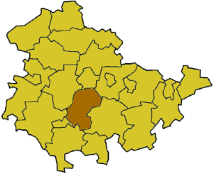
Ilm-Kreis is a district in
Thuringia ,Germany . It is bounded by (from the north and clockwise) the city ofErfurt , the districts ofWeimarer Land ,Saalfeld-Rudolstadt and Hildburghausen, the city ofSuhl , and the districts ofSchmalkalden-Meiningen and Gotha. It is named after the river Ilm, flowing through the district.History
In medieval times the territory was ruled by the counts of
Henneberg and the princes ofSchwarzburg , two local dynasties. WhileIlmenau was ruled by Henneberg, Arnstadt belonged to Schwarzburg. When the Henneberg family became extinct in 1583, Ilmenau was acquired bySaxony . In the meantime the principality of Schwarzburg began to disintegrate and was split up in several tiny states. One of those states (Schwarzburg-Arnstadt) was based in Arnstadt; it was founded in 1574 and existed until 1716, when it fell to Schwarzburg-Sondershausen. This mini state existed until 1920, when the state of Thuringia was founded.The district was founded in 1920 (under the name Arnstadt); it was divided in 1952 into the districts of Arnstadt and Ilmenau, but reunited in 1994.
Geography
In its southern portions the district includes parts of the southeastern
Thuringian Forest , among them the highest elevation of that mountain chain, including the Großer Beerberg (982 m). To the north the country is sloping away and becomes rather plain, mainly agricultural area.Coat of arms
External links
* [http://www.ilm-kreis.de Official website] (German, English)
Wikimedia Foundation. 2010.