Hildburghausen (district)
- Hildburghausen (district)
Infobox German district noregbez
name=Hildburghausen
state=Thuringia
capital=Hildburghausen
area=937
population=72,800
population_as_of=2002
density=78
carsign=HBN
url= [http://www.landkreis-hildburghausen.de landkreis-hildburghausen.de]
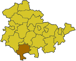
Hildburghausen is a district in Thuringia, Germany. It is bounded by (from the west and clockwise) the district of Schmalkalden-Meiningen, the city of Suhl, the districts of Ilm-Kreis, Saalfeld-Rudolstadt and Sonneberg, and the state of Bavaria (districts of Coburg, Haßberge and Rhön-Grabfeld). Located roughly halfway between the mountain chains of the Rhön and the Thuringian Forest, the district is densely forested and covered by hilly countryside. Its territory is similar to that of the former Ernestine duchy, Saxe-Hildburghausen.
Towns and municipalities
{|! colspan=3|Verwaltungsgemeinschaften
- valign=top
1. Feldstein
[seat: Themar]
#Ahlstädt
#Beinerstadt
#Bischofrod
#Dingsleben
#Ehrenberg
#Eichenberg
#Grimmelshausen
#Grub
#Henfstädt
#Kloster Veßra
#Lengfeld
#Marisfeld
#Oberstadt
#Reurieth
#Sankt Bernhard
#Schmeheim
2. Gleichberge
#Haina
#Mendhausen
#Milz
#Römhild1, 2
#Westenfeld
3. Heldburger Unterland
#Bad Colberg-Heldburg1, 2
#Gompertshausen
#Hellingen
#Schlechtsart
#Schweickershausen
#Ummerstadt2
#Westhausen
-
colspan=3 align=center|1seat of the Verwaltungsgemeinschaft;2town
Coat of arms
The coat of arms displays:
* the heraldic lion of Meißen, the precursor state to Saxony
* the cock representing the counts of Henneberg, who ruled the region until 1583
* below the symbol of the bishopric of Würzburg is displayed
External links
* [http://www.landkreis-hildburghausen.de/ Official website]
Wikimedia Foundation.
2010.
Look at other dictionaries:
Hildburghausen — Infobox German Location Art = Stadt image photo = Wappen = Hildburghausen coa.png lat deg = 50 |lat min = 25 |lat sec = 0 lon deg = 10 |lon min = 45 |lon sec = 0 Lageplan = Hildburghausen in HBN.png Bundesland = Thuringia Landkreis =… … Wikipedia
Hildburghausen (arrondissement) — Arrondissement de Hildburghausen Arrondissement de Hildburghausen Landkreis Hildburghausen … Wikipédia en Français
District de Suhl (RDA) — 50° 35′ 00″ N 10° 45′ 00″ E / 50.58333333, 10.75 … Wikipédia en Français
District de Greiz — Arrondissement de Greiz Arrondissement de Greiz Landkreis Greiz … Wikipédia en Français
Saxe-Hildburghausen — Duchy of Saxe Hildburghausen Herzogtum Sachsen Hildburghausen State of the Holy Roman Empire, State of the Confederation of the Rhine, State of the German Confederation … Wikipedia
Arrondissement de Hildburghausen — 50° 25′ N 10° 45′ E / 50.42, 10.75 … Wikipédia en Français
Eichenberg, Hildburghausen — Infobox Ort in Deutschland Name = Eichenberg image photo = Wappen = lat deg = 50 |lat min = 32 |lat sec = 0 lon deg = 10 |lon min = 40 |lon sec = 0 Lageplan = Eichenberg in HBN.png Bundesland = Thüringen Landkreis = Hildburghausen… … Wikipedia
Haina, Hildburghausen — Infobox Ort in Deutschland Name = Haina image photo = Wappen = Wappen Haina (Suedthueringen).png lat deg = 50 |lat min = 25 |lat sec = 0 lon deg = 10 |lon min = 31 |lon sec = 59 Lageplan = Haina in HBN.png Bundesland = Thüringen Landkreis =… … Wikipedia
Westhausen, Hildburghausen — Infobox Ort in Deutschland Name = Westhausen image photo = Wappen = lat deg = 50 |lat min = 19 |lat sec = 0 lon deg = 10 |lon min = 40 |lon sec = 0 Lageplan = Westhausen in HBN.png Bundesland = Thüringen Landkreis = Hildburghausen… … Wikipedia
Nordhausen (district) — Nordhausen District Country … Wikipedia