- Jerash Governorate
Infobox Settlement
official_name = Jerash Governorate
native_name = محافظة جرش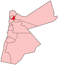
imagesize = 250px
image_caption = Jerash Governorate in Jordan.
subdivision_type =Country
subdivision_name =Jordan
area_magnitude = 1 E8
area_metro_km2 =
area_metro_sq_mi =
population_as_of = 2003
population_total =
population_metro =
population_footnotes =
timezone =GMT +2
utc_offset =
timezone_DST = +3
area_code = +(962)2
elevation_m = 600
elevation_ft = 1968Overview
Jerash ( _ar. جرش) is one of the governorates of
Jordan ; it is located north ofAmman , Jordan's capital. It carrys the name of its capital and largest city,Jerash City.Jerash Governorate has the second highest density in Jordan after Irbid Governorate.History
In the first century of the Christian era this insignificant city (then Gerasa) experienced a fast ascent under Roman rule and the
Pax Romana . It became part of theDecapolis and grew increasingly competitive with the olderPetra as a commercial town. The inhabitants won ore in the nearbyAjlun mountains. Starting in the middle of the First Century this upswing led to active building and a rich abundance of architectural monuments, still impressive today. In the Second Century the Roman expansion wars in Asia led to further gains. Well-made roads were built to Pella, Philadelphia (now Amman), Dion and to the provincial capital Bos(t)ra. EmperorHadrian visited the city in the winter of129 -130 . In the following centuries the political situation in this region changed fundamentally and the city's means declined. During this time also Christianity was on the ascendant and many churches were built. Gerasa had its own bishop—still today it is a Titularbistum—and bishop Placcus (or Plancus) participated in theCouncil of Chalcedon .Nicomachus of Gerasa came from this Gerasa.
Wikimedia Foundation. 2010.