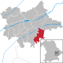
- Simbach, Dingolfing-Landau
-
Simbach 
Coordinates 48°34′0″N 12°45′0″E / 48.566667°N 12.75°ECoordinates: 48°34′0″N 12°45′0″E / 48.566667°N 12.75°E Administration Country Germany State Bavaria Admin. region Lower Bavaria District Dingolfing-Landau Local subdivisions 5 Ortsteile Mayor Herbert Sporrer (CSU) Basic statistics Area 51.23 km2 (19.78 sq mi) Elevation 440 m (1444 ft) Population 3,583 (31 December 2010)[1] - Density 70 /km2 (181 /sq mi) Other information Time zone CET/CEST (UTC+1/+2) Licence plate DGF Postal code 94436 Area code 09954 Website www.markt-simbach.de Markt Simbach is a municipality in the district Dingolfing-Landau, Bavaria, Germany. Population ca. 3800.(as of 2002[update]), area 51.24 km².
History
- 806 - first mentioning in official documents
- 13th century - received the title Markt
- 1496 - construction of the church St. Bartholomäus
- around 1634 - Plague
- 1658 - big fire
- 1670 - construction of 2nd school building (Deiritzhaus)
- 1736 - church was extended in baroque style
- 1972 - communal reform
References
- ^ "Fortschreibung des Bevölkerungsstandes" (in German). Bayerisches Landesamt für Statistik und Datenverarbeitung. 31 December 2010. https://www.statistikdaten.bayern.de/genesis/online?language=de&sequenz=tabelleErgebnis&selectionname=12411-009r&sachmerkmal=QUASTI&sachschluessel=SQUART04&startjahr=2010&endjahr=2010.
External links
Dingolfing | Eichendorf | Frontenhausen | Gottfrieding | Landau an der Isar | Loiching | Mamming | Marklkofen | Mengkofen | Moosthenning | Niederviehbach | Pilsting | Reisbach | Simbach | Wallersdorf Categories:
- Geography articles needing translation from German Wikipedia
- Municipalities in Bavaria
- Geography of Germany
- Dingolfing-Landau
- Lower Bavaria geography stubs
Wikimedia Foundation. 2010.


