- Muheza
-
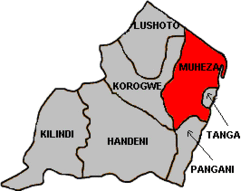
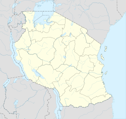
Muheza — District — Muheza District in Tanga Region Location in Tanzania Coordinates: 05°00′00″S 38°55′00″E / 5°S 38.9166667°ECoordinates: 05°00′00″S 38°55′00″E / 5°S 38.9166667°E Country  Tanzania
Region Tanga Region Government - Type District Council - District Commissioner Mathew Nasei Population (2002) - Total 278,405 Ethnicity - Bondei - Sambaa - Digo - Zigua - Segeju Time zone EAT (UTC+3) - Summer (DST) not observed (UTC+3) Area code(s) 027 Website tanga.go.tz Muheza is one of the eight districts of Tanga Region in Tanzania. It is bordered to the north by Kenya, to the east by the Tanga and the Indian Ocean, to the south by the Pangani District, and to the west by the Lushoto and Korogwe Districts.
According to the 2002 Tanzania National Census, the population of the Muheza District was 279,423.[1]
Wards
The Muheza District is administratively divided into 35 wards:
- Bwembwera
- Daluni
- Duga
- Gombero
- Kicheba
- Kigongoi
- Lusanga
- Kigombe
- Kilulu
- Kisiwani (English Meaning: on the island)
- Kwafungo
- Kwale
- Magila
- Magoroto
- Majengo (English Meaning: buildings)
- Manza
- Maramba
- Masuguru
- Mbaramo
- Mhinduro
- Misilai
- Misozwe
- Mkinga
- Mkuzi
- Moa
- Mtimbwane
- Mtindiro
- Mwakijembe
- Ngomeni
- Nkumba
- Pande
- Potwe
- Songa
- Tingeni
- Zirai
Sources
Categories:- Tanga Region
- Districts of Tanzania
- Tanzania geography stubs
Wikimedia Foundation. 2010.


