- Croes Newydd
-
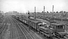
Croes Newydd was a large steam locomotive shed, marshalling yard and junction in Wrexham, in Wales.
History
Wrexham's Croes Newydd locomotive shed was the last of the GWR 'northlight' designs, being a roundhouse and depending on a central turntable for access. It was built by the Great Western Railway and opened in 1902, to replace outdated facilities at Wheatsheaf junction. It was located in the centre of a large fork junction, with the Chester to Shrewsbury line running along one edge, and the branch being the Wrexham and Minera Branch. The sheds also featured a GWR combined Water tower and coaling stage, of a design which was later to become standardised.
While the 'northlight' design was meant to allow maximum sunlight, the skylight windows quickly became sooted and black, reducing lighting conditions. The sheds stored several locomotives known as "workhorses" as they did the goods work. The last of these locomotives were the BR Standard 9F locomotives, the last of the British steam locomotives.
Under the cutbacks of BR in the 1960s, the shed finally closed in 1967.
After Closure
Between closure and the 1980s, Wrexham Corporation (now Wrexham County Borough Council) opened a yard and depot on part of the site. This was home to the town and surrounding area's rock salt store, as well as the grit spreaders that dispersed it in cold weather. Also kept here were all grass cutting equipment and road maintenance equipment. After sustaining damage from a minor fire in one of the buildings, the depot was closed and relocated to the nearby Wrexham Industrial Estate in 2009.
In the 1990s, sidings to the southwest of the triangle were developed as a suburban housing estate; Named Llys-David-Lord (David Lord Court), named after David Lord, a famed aviator. Apart from the sidings, the only thing left was an old BR Brake Van In the 2000s, the nearby Wrexham Maelor Hospital extended its car park onto the site of the marshalling yard to the west of the triangle.
Present Status
Now that the shed and marshalling yard were gone, the only remaining features were the Croes Newydd North and South Fork signal boxes. However the closure of the Wrexham and Minera Railway closed the South Fork signal box, leaving only the North Fork box as the only remaining box in the Wrexham area.
In 2010, Morrisons, a national supermarket chain, announced its intention to develop a majority of the remaining vacant land into a supermarket and adjoining car park.[1] This will be the first time in almost fifty years that the land has been occupied, and is being subjected to intense environmental rules, as over the years, the untamed scrub land and low lying debris from the original usage have formed natural habitats for a wide array of species. Some of the site will be retained as scrubland for possible future usage, and the route of the Northern fork of the Junction will be used as a path and cycleway to the level crossing near the North Fork Signal Box. This forms part of a route following the route of the Wrexham and Minera Railway as far as Moss Valley.
Categories:- Wrexham
- Transport in Wrexham county borough
Wikimedia Foundation. 2010.


