Angaston, South Australia
- Angaston, South Australia
Infobox Australian Place | type = town
name = Angaston
state = sa
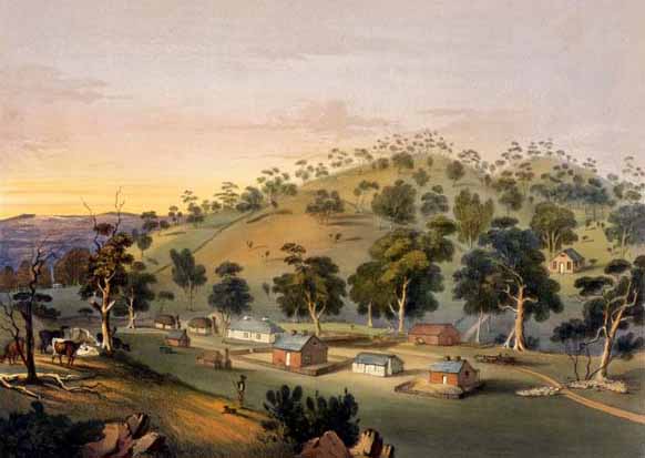
caption = Angaston painted by George French Angas in the 1840s
lga = Barossa Council
postcode = 5353
pop = 1,865 "2006 Census" [Census 2006 AUS]
id=UCL401000
name=Angaston (Urban Centre/Locality)
accessdate=2007-06-01
quick=on]
est = 1842
elevation= 347
maxtemp =
mintemp =
rainfall =
stategov = Schubert
fedgov = Wakefield
dist1 = 77
dir1 = north-east
location1= Adelaide via Angaston (coord|34|30|S|139|03|E|region:AU-SA_type:city) is a town in the Barossa Valley, South Australia, 77 km north east of Adelaide. Its elevation is 347 m, one of the highest points in the valley, and has an average rainfall of 561 mm. Angaston was originally known as "German Pass", but later was named after George Fife Angas, who settled in the area in the 1850s.
Angaston is in the Barossa Council local government area, the state electoral district of Schubert and the federal Division of Wakefield.
Wineries
* Yalumba
* Saltram Winery
Other Places
* Angas Park fruit shop
* The Union Chapel
* Collingrove Homestead
References
External links
* [http://www.angaston.com/ Angaston Community Portal]
* [http://www.southaustralianhistory.com.au/angaston.htm The history of Angaston]
Wikimedia Foundation.
2010.
Look at other dictionaries:
List of schools in South Australia — Government Schools Anangu and Aboriginal schoolsAboriginal Preschools and Kindergartens*Kalaya Children s Centre, Queenstown, South Australia *Kaurna Plains, Elizabeth, South Australia **Preschool School **Child CareAnangu schoolsLocated in the… … Wikipedia
Gawler South, South Australia — Infobox Australian Place | type = suburb name = Gawler South city = Gawler state = sa caption = lga = Town of Gawler postcode = 5118 pop = area = propval = stategov = Light fedgov = Wakefield near nw = Gawler West near n = Gawler near ne = Gawler … Wikipedia
Marino, South Australia — Marino Adelaide, South Australia Population: 1,986 (2006 Census)[1] Postcode: 5049 … Wikipedia
Nuriootpa, South Australia — Nuriootpa South Australia Memorial hall … Wikipedia
Moculta, South Australia — … Wikipedia
Penrice, South Australia — Penrice (coord|34|29|S|139|02|E|type:city region:AU SA) is a small town in the Barossa Valley of South Australia, just north of Angaston. It is the site of a large limestone and marble quarry operated by Penrice Soda Products.Penrice was named by … Wikipedia
Rail transport in South Australia — South Australia was the first colony in Australia to build a railway line. It was a horse drawn tramway from the port of Goolwa on the Murray River to an ocean harbour at Port Elliot in 1854. Today the state has RailGauge|1600 broad gauge… … Wikipedia
National War Memorial (South Australia) — National War Memorial Adelaide City Council Aerial view of the National War Memorial on North Terrace, Adelaide … Wikipedia
Mount Pleasant, South Australia — Mount Pleasant Population: 593 2006 Census [1] Established: 1843 Postcode … Wikipedia
Cockatoo Valley, South Australia — … Wikipedia