- Merrill Field
-
Merrill Field 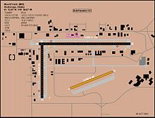
IATA: MRI – ICAO: PAMR – FAA LID: MRI Summary Airport type Public Owner Municipality of Anchorage Location Anchorage, Alaska Elevation AMSL 137 ft / 42 m Coordinates 61°12′49″N 149°50′40″W / 61.21361°N 149.84444°W Website Runways Direction Length Surface ft m 4/22 2,000 610 Gravel/Dirt 7/25 4,000 1,219 Asphalt 16/34 2,640 805 Asphalt Statistics (2004) Aircraft operations 191,550 Based aircraft 966 Source: Federal Aviation Administration[1] Merrill Field (IATA: MRI, ICAO: PAMR, FAA LID: MRI)[2] is a public-use general aviation airport located one mile (1.6 km) east of downtown Anchorage in the U.S. state of Alaska. The airport is owned by Municipality of Anchorage.[1]
This was the first official airport in Anchorage when it opened in 1930. The airport is named for Russel Merrill, an Alaskan aviation pioneer. The first aviation beacon in the Territory of Alaska was located at Merrill Field and was dedicated on September 25, 1932 in Merrill's honor.
Merrill Field is home to the University of Alaska Anchorage's Aviation Technology Division, as well as many local flight schools, air taxi services, and fixed base operators. An extension of the Q Taxiway connects the airport to Alaska Regional Hospital for MEDEVAC operations.
A section of the airport is built over the closed Merrill Field Land Fill. This section requires slightly more maintenance due to settling and emissions.
Contents
Facilities and aircraft
Merrill Field covers 436 acres (176 ha, 1.76 km²) and has three runways:[1]
- Runway 4/22: 2,000 x 60 ft (610 x 18 m), Surface: Gravel/Dirt
- Runway 7/25: 4,000 x 100 ft (1,219 x 30 m), Surface: Asphalt
- Runway 16/34: 2,640 x 75 ft (805 x 23 m), Surface: Asphalt
For 12-month period ending August 5, 2004, the airport had 191,550 aircraft operations, an average of 524 per day, 100% of which were general aviation. There are 966 aircraft based at this airport: 93% single engine, 5% multi-engine, 2% helicopters and <1% gliders.[1]
History
Merrill Field, located on the east end of 5th Avenue in Anchorage, Alaska, was the only airport serving Anchorage until 1951 when the introduction of ever larger and faster commercial aircraft required that an airfield with longer and heavier runways be built.
The airstrip is still in use today as the primary field for private wheel equipped aircraft in the warmer months and for ski equipped in the winter.
References
- ^ a b c d FAA Airport Master Record for MRI (Form 5010 PDF), effective 2007-03-15
- ^ Great Circle Mapper: MRI / PAMR - Anchorage, Alaska (Merrill Field)
External links
- [2] Municipality of Anchorage: Merrill Field (official web site)
- Alaska FAA airport diagram (GIF)
- FAA Airport Diagram for Merrill Field (PDF), effective 20 October 2011
- Resources for this airport:
- AirNav airport information for PAMR
- ASN accident history for MRI
- FlightAware airport information and live flight tracker for PAMR
- NOAA/NWS latest weather observations for PAMR
- SkyVector aeronautical chart for MRI
Categories:- Airports in Anchorage, Alaska
- University of Alaska Anchorage

Wikimedia Foundation. 2010.