- Gakkel Ridge
-
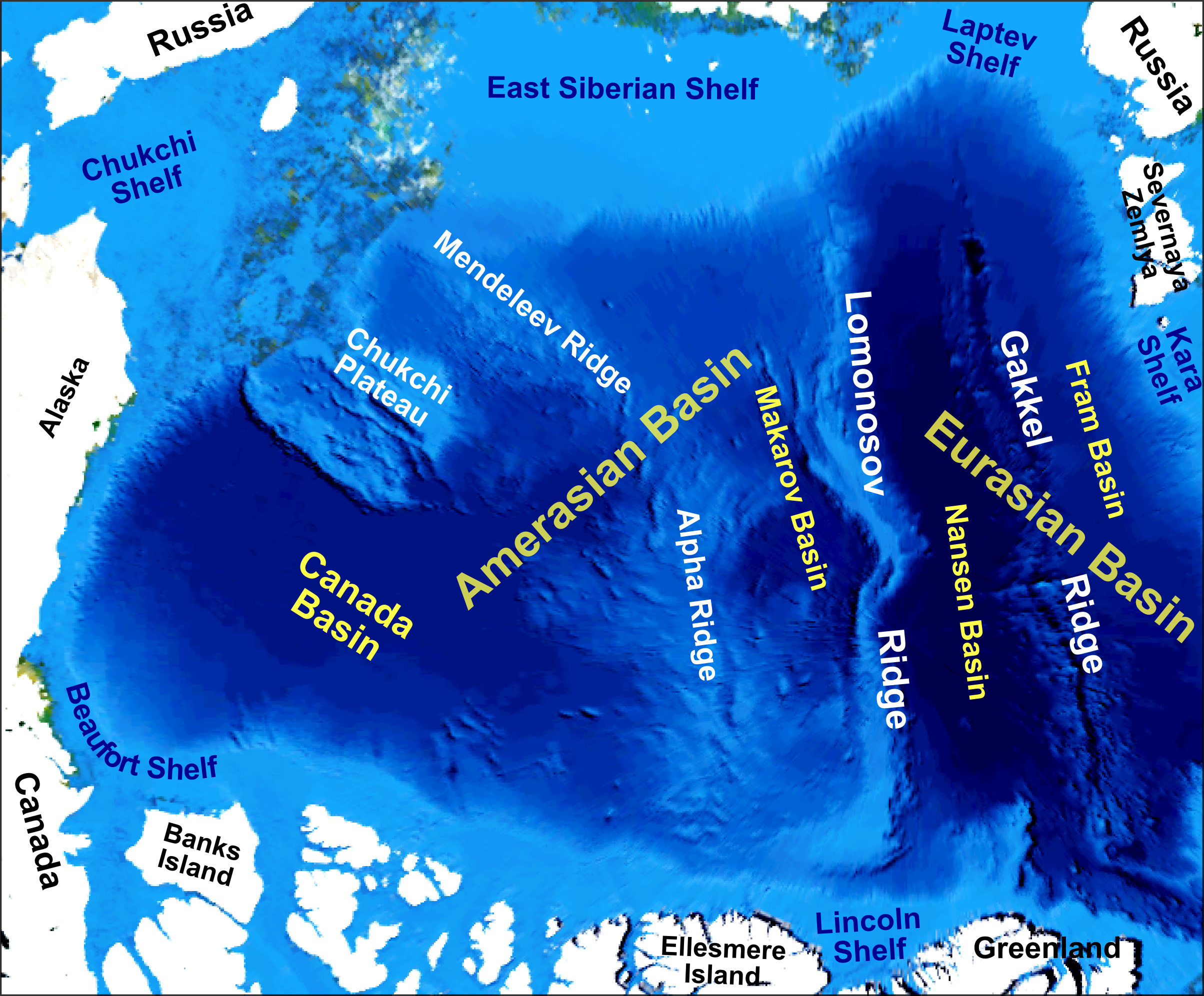
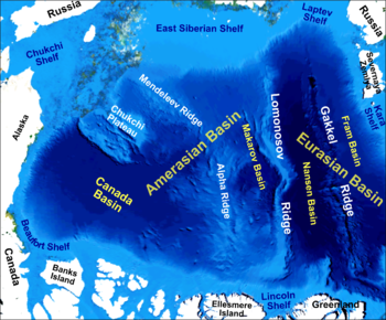 Main bathymetric/topographic features of the Arctic Ocean
The Gakkel Ridge (formerly known as the Nansen Cordillera and Arctic Mid-Ocean Ridge)[1] is a mid-oceanic ridge, a divergent tectonic plate boundary between the North American Plate and the Eurasian Plate.[2] It is located in the Arctic Ocean between Greenland and Siberia, and has a length of about 1,800 kilometers. Geologically, it connects the northern end of the Mid-Atlantic Ridge with the Laptev Sea Rift.
The existence and approximate location of the Gakkel Ridge were predicted by Soviet polar explorer Yakov Yakovlevich Gakkel, and confirmed on Soviet expeditions in the Arctic around 1950. The Ridge is named after him, and the name was recognized in April 1987 by SCUFN (under that body's old name, the Sub-Committee on Geographical Names and Nomenclature of Ocean Bottom Features).[1]
The ridge is the slowest known spreading ridge on earth, with a rate of less than one centimeter per year. Until 1999, it was believed to be non-volcanic; that year, scientists operating from a nuclear submarine discovered active volcanos along it. In 2001 two research icebreakers, the German Polarstern and the American Healy, with several groups of scientists, cruised to the Gakkel Ridge to explore it and collect petrological samples. Among other discoveries, this expedition found evidence of hydrothermal vents. In 2007, Woods Hole Oceanographic Institution conducted the "Arctic Gakkel Vents Expedition" (AGAVE), which made some unanticipated discoveries, including the unconsolidated fragmented pyroclastic volcanic deposits that cover the axial valley of the ridge (whose area is greater than 10 km2). These suggest volatile substances in concentrations ten times those in the magmas of normal mid-ocean ridges.[3] The AGAVE expedition also discovered on the Gakkel ridge, using "free-swimming" robotic submersibles, what they called "bizarre 'mats' of microbial communities containing a half dozen or more new species".[4]
References
- ^ a b "IHO-IOC GEBCO Gazetteer" (PDF). International Hydrographic Organization/Intergovernmental Oceanographic Commission. September 2007. http://www.gebco.net/about_us/meetings_and_minutes/documents/gebco_scufn_15_report.pdf. Retrieved 2008-05-24.
- ^ "GPS Measurements Reveal Imprint of North American Plate in Siberia", Earth Institute at Columbia University, 2003
- ^ Robert A. Sohn, et. al., Explosive volcanism on the ultraslow-spreading Gakkel ridge, Arctic Ocean, Nature 453, 1236-1238 (26 June 2008) | doi:10.1038/nature07075 http://www.nature.com/nature/journal/v453/n7199/full/nature07075.html (abstract)
- ^ http://www.ridge2000.org/dls/abstracts.php The Arctic Gakkel Vents (AGAVE) Expedition: A High–Stakes Technology Gamble Pays Big Dividends Beneath the Arctic Ice Cap, Ridge 2000 Abstracts 2009
Further reading
- Jokat, Wilfried, and Mechita C. Schmidt-Aursch. 2007. "Geophysical Characteristics of the Ultraslow Spreading Gakkel Ridge, Arctic Ocean". Geophysical Journal International. 168, no. 3: 983-998.
External links
- Polar Discovery: Gakkel Ridge
- http://diotima.mpch-mainz.mpg.de/~geo/Arctic/index.html
- http://www.geolsoc.org.uk/template.cfm?name=Gakkel
- http://www.nature.com/cgi-taf/DynaPage.taf?file=/nature/journal/v421/n6920/abs/nature01351_r.html
- http://www.noaanews.noaa.gov/stories/s1081.htm
- http://news.yahoo.com/s/ap/20070622/ap_on_sc/arctic_new_life
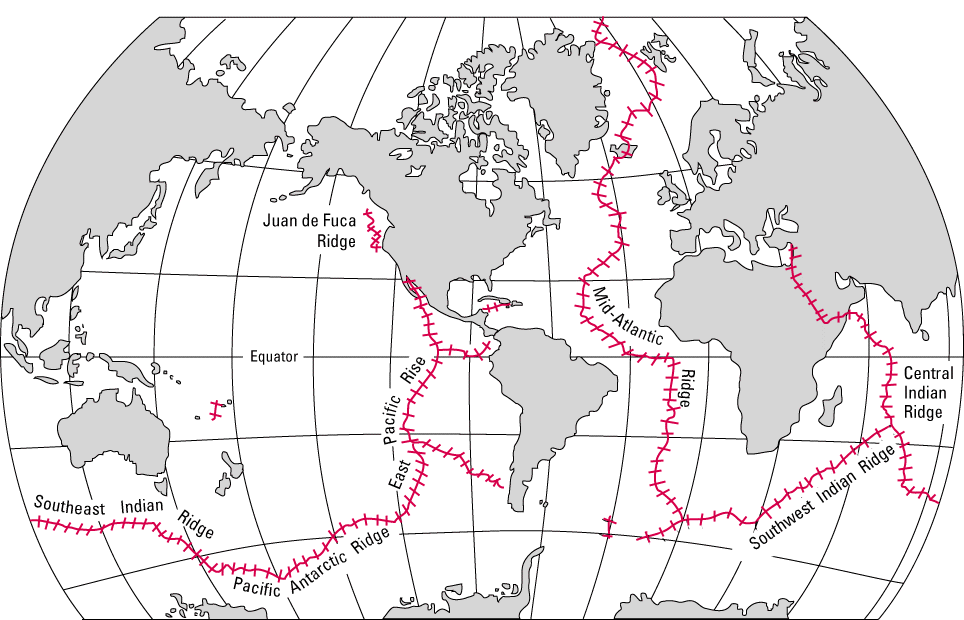
Mid-ocean ridges Present American-Antarctic · Chile · East Pacific · Explorer · Gakkel · Gorda · Juan de Fuca · Mid-Atlantic · Pacific–Antarctic · Central Indian · Southeast Indian · Southwest Indian
Former Categories:- Underwater ridges of the Arctic Ocean
Wikimedia Foundation. 2010.