- Aukštaitija National Park
-
Aukštaitija National Park 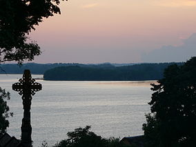
Lūšiai lake in PalūšėLocation Lithuania Nearest city Ignalina Coordinates 55°20′38″N 26°03′25″E / 55.344°N 26.057°ECoordinates: 55°20′38″N 26°03′25″E / 55.344°N 26.057°E Area 405.70 km² Established 1974 Aukštaitija National Park is a national park in northeastern Lithuania, about 100 km north of Vilnius. Established in 1974, it is the oldest of the five national parks in Lithuania. At first it was named Lithuanian SSR National Park to emphasize that it was the first such park in the republic. In 1991, four other parks were established and were renamed after ethnographic regions of Lithuania. The park was renamed after Aukštaitija.
Park territory occupies 405.7 km². Ignalina district municipality controls about 50% of the area. Utena and Švenčionys district municipalities control 25%. Strictly protected areas occupy 2.1%. One can enter this territory only with accompanying employee of the park. Over 70 percent of its territory is covered by woods. 80 percent of woods are pine stands, some reaching 200 years old.
Sixty-four species of plants, eight species of fungi, and 48 species of birds that are found in the park are included in the Red book of Lithuania. The park is famous for its biodiversity - 59% of all plant species in Lithuania can be found in the park which covers less than 1% of Lithuania's territory.
Contents
Waters
 View from Ladakalnis hill
One hundred twenty-six lakes are scattered among the woods and hills. They are often interconnected by rivulets and streams and is a popular site for water tourism with kayaks. Since the park was established over 30 years ago, infrastructure for water tourism is well-developed. There are many sites to rent a boat or a kayak and also for people to rest overnight. The lakes cover 59.30 km² (or 15.5%) of the park territory. The largest of the lakes is Lake Kretuonas (8.29 km²). Lake Tauragnas, the deepest in Lithuania (60.5 m), is also here. There are 14 lakes that are bigger than 1 km². Six lakes are between 0.5 and 1 km² and 35 lakes - 50 and 5 ha. The rest are smaller than 5 ha and some of them are slowly turning into swamps.
The Baluošas lake features seven islands, one of which has a little lake of its own. A small stream flows from this lake to Baluošas. This makes it a unique lake in Lithuania. The largest river is Žeimena (22 km in the park territory, up to 114 km in total). It is a very clean river that flows into Neris. All lakes and rivulets belong to the Žeimena basin.
One of the most famous sights in the Park is Ladakalnis hill, from top of which six lakes can be seen. It is a geomorphological monument.
Villages
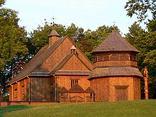 18th century wooden church in Palūšė
There are 116 villages in the park with about 2300 residents. The first villages are mentioned in the 14th century (Vilnius, the capital of Lithuania, was first mentioned in written sources in 1323). The most famous of the villages is Palūšė where park administration resides. Its church, built in 1750, is considered to be the oldest surviving wooden church in Lithuania and was featured on 1 litas banknote. Stripeikiai is the oldest village in the park, now known for its unique Lithuanian Museum of Ancient Beekeeping. Ginučiai is another famous village, and tourists are attracted by its 19th century watermill. Being one of the few mills that still has the original mechanisms, it is declared an engineering monument. Two hill forts of national importance are nearby. Kaltanėnai town with 300 inhabitants is the biggest settlement.
A classical 1972 Lithuanian movie about an outlaw and national folk hero Tadas Blinda was filmed in Šuminai village. This and five other villages are declared architectural monuments.
Archaeology
 In beekeeping museum in Stripeikiai
Random findings show that people lived in the area about 9000-8000 years BCE. More abundant artifacts come from about 3000 BCE. It is considered that the oldest settlements were established in the area. There are 45 burial sites built in the 4th-12th centuries. The sites feature from several to 400 tumuluses (usually a couple meters in diameter, but the biggest one is 20 meters). A tumulus is usually surrounded by a ring of stones or a shallow ditch. People were buried together with things they might need in the afterlife - jewelry, tools, guns, even horses. The park also has 11 hillforts.
External links
National parks of Lithuania Aukštaitija · Dzūkija · Kuršių Nerija · Trakai · Žemaitija
Categories:- IUCN Category II
- National parks of Lithuania
- Utena County
- Protected areas established in 1974


Wikimedia Foundation. 2010.