Clayton Farm Heritage Museum
- Clayton Farm Heritage Museum
-

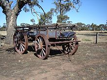
An old wagon situated at the museum.
Clayton Farm Heritage Museum is the former home of the Wiese family located off Naracoorte Road on the outskirts of Bordertown, South Australia. It consists of a group of historical thatched buildings and sheds, including the largest thatched structure in the Southern Hemisphere. The historic farm homestead dates back to 1885 with a woolshed dating back to 1901. Volunteers have spent over 20 years restoring the homestead, stocking it with a substantial collection of restored historical farm machinery and stationary engines.
The Wiese family occupied Clayton Farm until 1981, when Jeff Wiese reached an agreement with the Bordertown and District Agricultural Museum to lease an area of 3.48 hectares of land containing an outstanding collection of historic buildings.[1] In February 2004 a fire swept through the museum and destroyed several sheds and some machinery. It was feared the museum would be closed but rebuilding has begun.[1]
References
External links
Coordinates: 36°19′54″S 140°45′31″E / 36.3316°S 140.7587°E / -36.3316; 140.7587
Categories:
- Visitor attractions in South Australia
- Agriculture museums in Australia
- Museums in South Australia
- Historic house museums in Australia
- Farms in Australia
- Farm museums
- Australia museum stubs
Wikimedia Foundation.
2010.
Look at other dictionaries:
Florida Museum of Natural History — Coordinates: 29°38′09″N 82°22′13″W / 29.63583°N 82.37028°W / 29.63583; 82.37028 … Wikipedia
List of museums in England — Museums in England is a link page for any museum in England by ceremonial county. The Museums, Libraries and Archives Council is the national development agency for museums in England, and is a sponsored body of the Department for Culture, Media… … Wikipedia
Atlanta — This article is about the city in the U.S. state of Georgia. For other uses, see Atlanta (disambiguation). Atlanta … Wikipedia
Martin Luther King, Jr., National Historic Site — This article is about the National Historic Site in Atlanta, GA. For the article about the Memorial in Washington, D.C., see Martin Luther King, Jr. Memorial King, Martin Luther, Jr., National Historic Site and Preservation District U.S. National … Wikipedia
Nationality Rooms — Coordinates: 40°26′40″N 79°57′12″W / 40.444426°N 79.953423°W / 40.444426; 79.953423 … Wikipedia
Davison's Mill, Stelling Minnis — Davison s Mill, May 2010 Origin Mill name Davison s Mill Grid reference … Wikipedia
Chillenden Windmill — Origin Grid reference … Wikipedia
Greensboro, North Carolina — Greensboro redirects here. For other uses, see Greensboro (disambiguation). Greensboro City City of Greensboro … Wikipedia
Johnston County, North Carolina — Infobox U.S. County county = Johnston County state = North Carolina map size = 250 founded = 1746 seat = Smithfield | area total sq mi =796 area land sq mi =792 area water sq mi =4 area percentage = 0.50% census yr = 2007 pop = 157,437 density… … Wikipedia
Norwegian American — Norskamerikanere … Wikipedia

