Minilya, Western Australia
- Minilya, Western Australia
-
This article is about the region in Australia. For the
bryozoan genus, see Minilya (bryozoan).
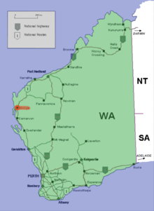
Location of Minilya in Western Australia (red)
Minilya is a location in Western Australia north of Carnarvon on the North West Coastal Highway. It is at a junction in the North West Coastal Highway, where the turn off to Exmouth is 220 kilometres from that location. The main highway then continues to the next junction 217 kilometres further, at Nanutarra Roadhouse. At the 2006 census, Minilya had a population of 137.[1]
Notes and references
See also
Categories:
- Towns in Western Australia
- Roadhouses in Western Australia
- Western Australia geography stubs
Wikimedia Foundation.
2010.
Look at other dictionaries:
Nanutarra, Western Australia — is a locality adjacent to where the Ashburton river is crossed by the North West Coastal Highway. It is also close to the turn off for route 136 to Paraburdoo and Tom Price [1]. It is 40 kilometres south of the Onslow turnoff in the Cane River… … Wikipedia
List of roadhouses in Western Australia — Western Australia has extensive long distance highways that have few localities spaced on them so the presence of roadhouses as an important utility for accommodation, emergency facilities, petrol and supplies cannot be under rated.Nullarbor or… … Wikipedia
Timeline of Aboriginal history of Western Australia — This is a Timeline of Aboriginal history of Western Australia 1629 1829Aboriginal life in the two centuries from 1629 to 1829, was characterized by the increased presence of Europeans around the Western Australian coastline. First contact,… … Wikipedia
List of pastoral leases in Western Australia — Pastoral leases are increasingly known as stations , and more particular as either sheep stations or cattle stations. They are usually found in country that is designated as rangeland. In Western Australia, all leases are up for renewal or… … Wikipedia
Minilya River — Mouth Lake MacLeod Basin countries Australia Length 210 kilometres (130 mi) Source elevation 275 metres (902 ft)[1] … Wikipedia
North West Coastal Highway — Length 1320 km (820 mi) Direction Southwest Northeast From … Wikipedia
Shire of Carnarvon — Infobox Australian Place | type = lga name = Shire of Carnarvon state = wa imagesize= 180 caption = Location in Western Australia pop = 5,681 (2006 census) area = 46663.5 est = 1890s seat = Carnarvon mayor = Dudley Maslen region = Gascoyne url =… … Wikipedia
2010–11 Australian region cyclone season — Season summary map First storm formed: 28 October 2010 Last storm dissipated: 10 April 2011 … Wikipedia
Australische Zyklonsaison 2010–2011 — Alle Stürme der Saison Bildung des ersten Sturms 28. Oktober 2010 Auflösung des letzten Sturms 20. April 2011 … Deutsch Wikipedia
North West Coastal Highway — Der North West Coastal Highway ist Teil des Highways 1 Der North West Coastal Highway in Western Australia ist eine Nord Süd Autobahn, die den Fischereihafen Geraldton mit dem Eisenerzhafen Port Hedland verbindet. Die zweispurige Fahrbahn ist… … Deutsch Wikipedia

