- Nishnabotna River
-
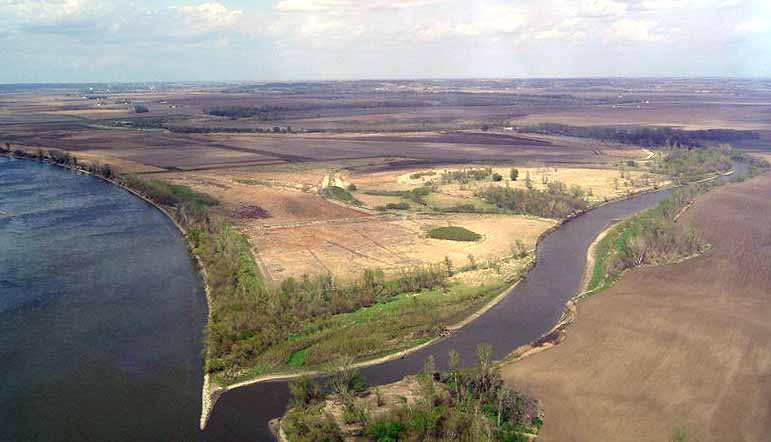
 The mouth of the Nishnabotna River at the Missouri River viewed from the southwest
 Flooding (and levee breach) at the confluence on June 16, 2011, during the 2011 Missouri River floods viewed from the northeast
The Nishnabotna River is a tributary of the Missouri River in southwestern Iowa, northwestern Missouri and southeastern Nebraska in the United States. It flows for most of its length as two parallel streams in Iowa, the East Nishnabotna River and the West Nishnabotna River. The east and west branches are each about 120 miles (190 km) long; from their confluence the Nishnabotna flows approximately another 16 miles (26 km).[1]
Several sections of the rivers' courses have been straightened and heavily channelized.
The name "Nishnabotna" comes from a Native American word meaning "canoe-making river."
Contents
Course
East Nishnabotna River
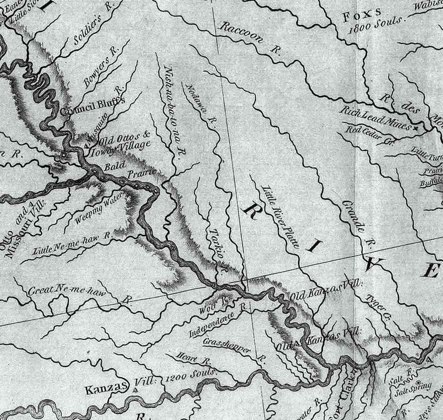
 This excerpt from the Lewis and Clark map of 1814 shows the rivers of southwest Iowa, southeast Nebraska, and northwest Missouri. The "Nish-na-bot-to-na River" is seen in the west-central portion of the map.
The East Nishnabotna rises in southwestern Carroll County and flows generally south-southwestwardly through Audubon, Cass, Pottawattamie, Montgomery, Page and Fremont Counties, past the towns of Exira, Brayton, Atlantic, Lewis, Elliott, Red Oak and Riverton.
West Nishnabotna River
The West Nishnabotna River rises in southwestern Carroll County and also flows generally south-southwestwardly through Crawford, Shelby, Pottawattamie, Mills and Fremont Counties, past the towns of Manning, Irwin, Kirkman, Harlan, Avoca, Hancock, Oakland and Carson. At Harlan it collects the West Fork West Nishnabotna River, which rises in southwestern Carroll County and flows southwestwardly through Crawford and Shelby Counties, past Manilla and Defiance. Near Avoca it collects the East Branch West Nishnabotna River, which rises in southwestern Carroll County and flows southwestwardly through Audubon, Shelby and Pottawattamie Counties, past Gray. The West Nishnabotna was the topic of a humorous song on the 1974 C.W. McCall albums Wolf Creek Pass and Rubber Duck.
Lower river
The East and West rivers merge in southwestern Fremont County and continue as the Nishnabotna River for its short course past Hamburg and into northwestern Atchison County, Missouri, where it flows into the Missouri River 2 mi (3 km) west of Watson.
The Nishnabotna River enters Nemaha County, Nebraska for about 0.5 mi (0.8 km) just above the confluence with the Missouri River; the Nebraska-Missouri state line runs to the east of the Missouri River in this area. [1], [2]
Recreation
Parks along the river include Botna Bend in Hancock, Willow Slough Wildlife Management Area 3 miles southwest of Henderson, and Riverton Wildlife Management Area, just north of Riverton. Canoe rentals are available at Botna Bend. The best paddling is between Hancock and Carson on the west fork and between Lewis and Griswold on the east fork (see "Paddling Iowa" by Nate Hoogeveen). The Wabash Trace hiking trail crosses both forks. At its crossing of the west fork one can see the wreckage of a freight train that derailed and went into the drink in the 1960s.
Variant names
According to the Geographic Names Information System, the river has also been known as:
- Good Canoe River
- Nishabotna River
- Nishabotny River
- Nishabotony River
- Nishebotona River
- Nishnabotony River
- Nishnebotna River
- Nishnebotne River
- Nishnebotona River
- Nishnebottona River
- Willo River
- Willow Slough
Trivia
- The Nishnabotna is mentioned in C.W. McCall's Four Wheel Drive, where it is sarcastically referred to as being "a yard wide and a foot deep."
- The West Nishnabotna is mentioned in the 2008 Marilynne Robinson novel Home: A hundred yards ahead of them was the bridge across the West Nishnabotna (page 163)
See also
- List of Iowa rivers
- List of Missouri rivers
- List of Nebraska rivers
- Mormon Trail
Sources
- ^ U.S. Geological Survey. National Hydrography Dataset high-resolution flowline data. The National Map, accessed March 30, 2011
- Columbia Gazetteer of North America entry
- DeLorme (1998). Iowa Atlas & Gazetteer. Yarmouth, Maine: DeLorme. ISBN 0-89933-214-5.
- DeLorme (2002). Missouri Atlas & Gazetteer. Yarmouth, Maine: DeLorme. ISBN 0-89933-353-2.
- GNIS entries for U.S. Geological Survey Geographic Names Information System: Nishnabotna River, U.S. Geological Survey Geographic Names Information System: East Nishnabotna River, U.S. Geological Survey Geographic Names Information System: West Nishnabotna River, U.S. Geological Survey Geographic Names Information System: East Branch West Nishnabotna River, U.S. Geological Survey Geographic Names Information System: West Fork West Nishnabotna River
Coordinates: 40°30′52″N 95°40′38″W / 40.5145°N 95.6773°W
Categories:- Rivers of Iowa
- Rivers of Missouri
- Rivers of Nebraska
- Tributaries of the Missouri River
- Geography of Otoe County, Nebraska
- Geography of Nemaha County, Nebraska
- Geography of Carroll County, Iowa
- Geography of Audubon County, Iowa
- Geography of Cass County, Iowa
- Geography of Pottawattamie County, Iowa
- Geography of Montgomery County, Iowa
- Geography of Page County, Iowa
- Geography of Fremont County, Iowa

Wikimedia Foundation. 2010.